

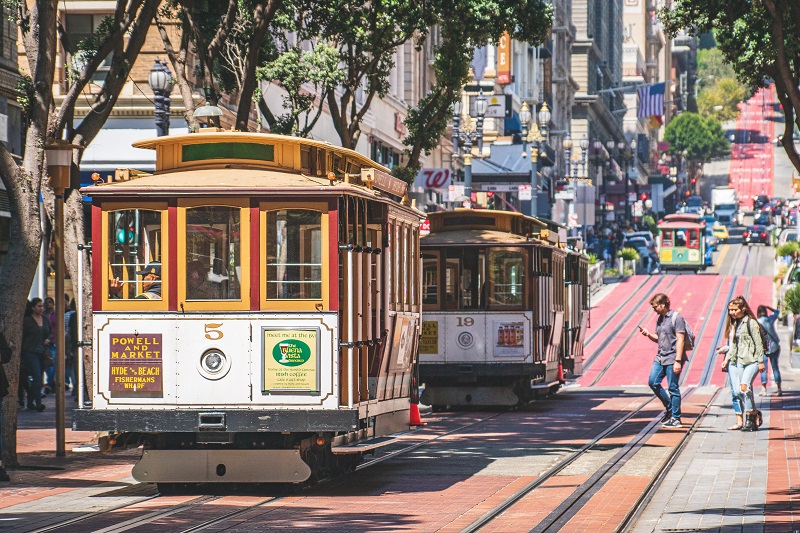
San Francisco’s streetcars are one of the city’s most charming and popular landmarks. In the steep streets, the cable-drawn trams bounce up and down, and one exciting sight replaces the other for passengers inside and outside the carriages.
The trams run like cable cars that are pulled by large cables from central locations such as the Cable Car Barn. Here you can see the large wheels and the machinery that pulls the cables, which in turn pull the carriages on the remaining Cable Car lines.
The history of the trams goes back to 1869, when the Englishman Andrew Hallidie experienced an accident with the horse-drawn carriages that then ran through some of the city’s streets. The accident claimed the lives of five horses and Hallidie wanted to do something to prevent a repeat.
In 1873, Andrew Hallidie opened the first cable-operated streetcar in San Francisco. It was the Clay Street Hill Railroad, and it was such a great success that in the period 1873-1890, 23 cable car lines were built in the city. After 1890, the transition to electric trams instead of cable-drawn tracks started, and over the following decades cable cars were discontinued or converted to electric operation.
In 1906, a major earthquake hit San Francisco, and the quake and subsequent fires destroyed most of the city’s cable car infrastructure. This allowed for continued conversion to electric operation, but in 1912 there were still eight cable car lines in operation. These lines ran along streets that were too steep for electric lines.
Throughout the 1920s and 1930s, many new and improved buses were developed to run on the remaining cable car lines, and by 1944 only five lines remained; two were in public ownership and three in the company Cal Cable. In 1947, the mayor of San Francisco proposed closing the city’s two lines, but this was voted down by a vote of the city’s citizens. In 1951, Cal Cable closed the lines, which the city government took over and then reopened. However, only the California Street line was preserved.
Over the years, the tram lines were modernised, and new old-style carriages were also built to supplement existing stock. This can be experienced today on the three lines in operation; Powell/Hyde Line, Powell/Mason Line and California Line. The line names indicate the streets along which the carriages travel.
Technically, the cable car lines still run as they did in the 1800s. There are 3.2 centimeter thick cables in the streets, which are pulled at a speed of 15.3 kilometers per hour. The cables are pulled from a central location, and the so-called gripman in the carriages opens and closes the grip on the cables to drive or stop.
In addition to the cables that pull the cars forward and brake them during descents, the individual cable cars also have three different types of brakes. There are metal brake pads, wooden brake pads and a steel emergency brake.
There are differences between the individual lines. The Powell/Hyde Line and the Powell/Mason Line both have the famous turntables at the terminus. The carriages on these lines can only run in one direction and must therefore be turned around after each trip. This is done manually and to the great delight of spectators. The carriages on the California Line can run in both directions and therefore do not have to be turned around.
The machine house, where the network’s cables are pulled from, is the Cable Car Barn (1201 Mason Street) from 1907. It is today both a working part of the streetcar system and a museum of the history of streetcars in San Francisco. At the museum you can learn more about the history of the cable car system, see old equipment and understand the technology behind the popular cable cars.
San Francisco is known for its iconic cable cars, which are cable-drawn trams that are pulled through the city’s steep streets. However, there is also another notable transportation option in San Francisco’s extensive transportation network; namely the F Market & Wharves tram line.
Streetcar Line F is a conventional streetcar line operated with old and charming streetcars that run in regular service in the San Francisco transportation system. The line serves Fisherman’s Wharf, the Embarcadero, the Ferry Building, Market Street and The Castro, so many of the city’s attractions are within close proximity of the stops.
The trams on the route are rolling sights that many passengers enjoy. The material consists of a mixture of old carriages from San Francisco and from many other cities around the world. The primary carriage model is the so-called PCC, President’s Conference Committee, whose design originates from the USA of the 1930s. The PCC wagon was produced in the years 1936-1952, and in a large number of other countries it was produced under license in adapted variants. In the USA, the wagons were produced by both St. Louis Car Company and by Pullmann Standard, while production in Europe took place in Bruges, Chorzów, Prague and Zaragoza, among others.
If you take line F today, you can travel with PCC cars from not least San Francisco, Philadelphia and Newark. These wagons date from the 1940s. In addition, there are several carriages of the Peter Witt type, which come from Milan, Italy. These wagons were built in 1928 in Italy from a design known from many American cities. You may also come across other carriages on the line; eg old San Francisco carriages from the years 1895-1924.
The opening of the line in San Francisco happened gradually from 1983, when old trams had been used experimentally during the period when San Francisco’s cable cars were closed for two years for a complete renovation. The temporary periods of traffic continued until 1987, when a permanent, historic line was discussed. The current line F was opened in 1995 using the old carriages.
Pier 39 is one of San Francisco’s many piers and probably the best known of them all. The current pier was established in 1977, and old wood from Pier 3 and Pier 34 was used for the construction, among other things. In 1978, Pier 39 opened with shops, restaurants and other entertainment, and this concept has continued and developed to this day.
There are many activities on the long pier. You can, for example, take a trip on the well-known carousel at Pier 39 or enjoy the view over San Francisco Bay to the Golden Gate Bridge, the Oakland Bay Bridge and the prison island of Alcatraz. You can also visit the Aquarium of the Bay, where you can take a closer look at the marine life in San Francisco Bay.
Pier 39 is also home to San Francisco’s famous sea lion colony, which is a draw for locals and tourists alike. The sea lions settled at Pier 39 in 1989, where they previously used Seal Rock as a colony. The sea lions used berths, and in the early days the boats had to navigate around the sea lions before the animals got the whole area at Pier 39.
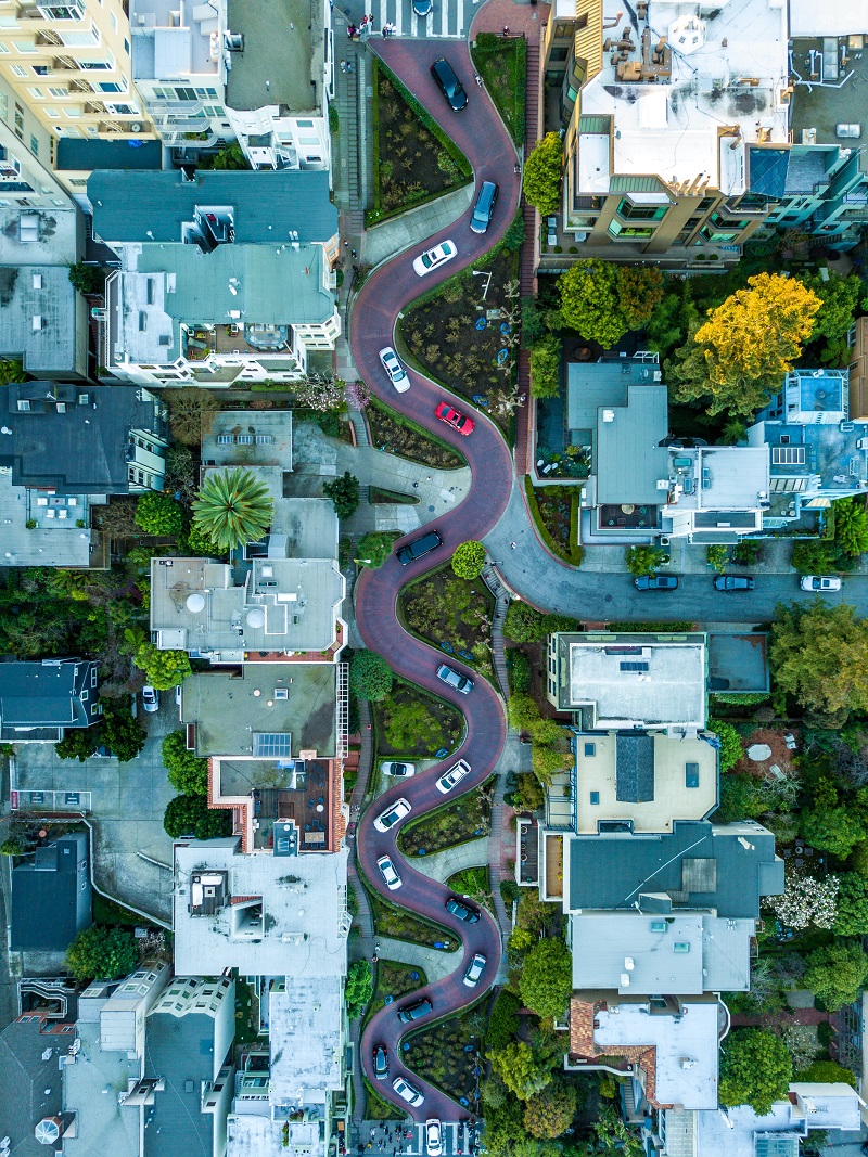
Lombard Street is also called America’s most winding street, and for good reason. Between Victorian houses, Lombard Street descends steeply through hairpin turns on the section between Hyde Street and Leavenworth Street. There are as many as eight bends in the few hundred meters that the short section measures.
The street is fun to walk or drive down and there are many beautiful flowers throughout the summer season. You can easily get to the top with the San Francisco Cable Car, and from here you can go down to the east. If you want to see the street from above, you can go to the top of Coit Tower, from where you can really see the winding course of the street.
The Presidio of San Francisco is a park and former military site on the northern tip of the San Francisco Peninsula. It was the Spanish who established the fort El Presidio Real de San Francisco on the site in 1776, and they did so to establish themselves at the entrance to California Alta and the area around San Francisco Bay. The fort later became Mexican, and it belonged to the US defense from 1848 to 1994.
Today, the Presidio is a large recreational area that, among other things, offers vantage points with fine views of the Pacific Ocean, San Francisco Bay and the famous Golden Gate Bridge, which spans the Golden Gate Strait.
If you want to know more about the Presidio’s history from its establishment to the present day, you can start your visit at the Presidio Visitor Center (210 Lincoln Boulevard). In the visitor center there is also information about activity options in the park.
Among the most popular sites in the Presidio of San Francisco is Fort Point, located to the north and immediately adjacent to the abutment of the Golden Gate Bridge. In this area, you can also see the Golden Gate Bridge Pavilion, which opened as a visitor center for the bridge in 2012. There are also beaches in the park; from East Park in the east to Baker Beach in the west, there are several options, all connected by walking trails, of which the Golden Gate Promenade and the Coastal Trail are among the most popular.
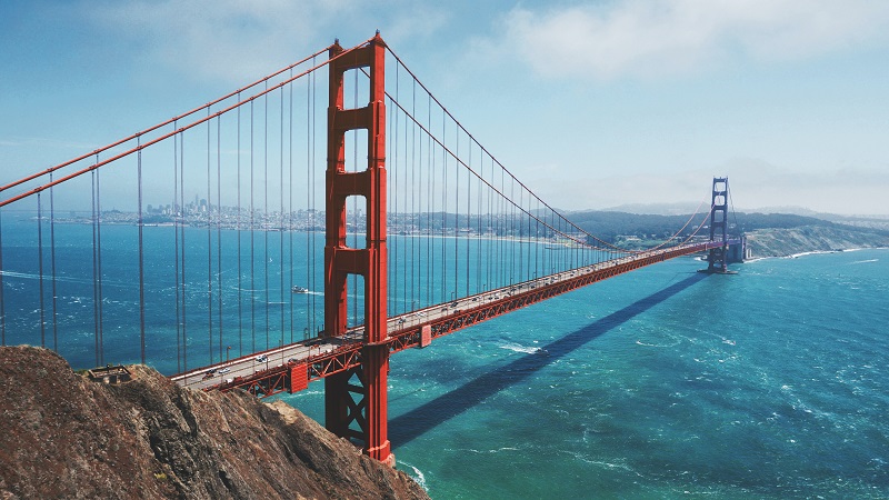
The Golden Gate Bridge is a suspension bridge that spans the inlet from the Pacific Ocean to San Francisco Bay, a strait named the Golden Gate. The bridge is probably San Francisco’s best-known landmark and one of the USA’s most famous buildings.
The length of the Golden Gate Bridge is 2,737 meters long, and it reaches a height of 227 meters. The clear span between the bridge’s pylons is 1,280 metres, and there are 67 meters under the bridge at high tide.
The impressive bridge was built in the years 1933-1937, and when it opened, the Golden Gate Bridge was both the world’s highest suspension bridge and the bridge with the largest free span.
With the Golden Gate Bridge, it became possible to cross the strait north of the San Francisco Peninsula in a short time. Before that, there were ferry crossings starting in 1820. The ferries became one of the city’s main means of transportation, and there were departures from Hyde Street Pier and the Ferry Building to Sausalito. The fastest trip took 20 minutes, but San Francisco’s location and the ferries were a brake on the city’s development compared to other major American cities.
The idea for the Golden Gate Bridge was not new when a new article about a bridge was published in 1916. In it, James Wilkins as a municipal engineer estimated that the project would cost 100 million dollars, which was not feasible. Wilkins asked bridge engineers for proposals for cheaper solutions, and Joseph Strauss submitted a proposal for $17 million.
Strauss’ proposal was chosen, but it had to be radically changed; e.g. for a suspension bridge, which was not Strauss’ proposed solution. Joseph Strauss became the bridge’s chief engineer, but Leon Moisseiff was responsible for the actual suspension bridge design; he had been an engineer on the Manhattan Bridge project in New York. Many of the bridge’s decorative details were designed by Irving Morrow; this applied, for example, to lampposts, railings and the visual details of the pylons, which are in the art deco style.
Construction of the bridge began in 1933, and the final cost was approximately $35 million. The opening of the new link took place on 27 May 1937. The opening celebrations lasted for a week, and the day before car traffic the bridge was open to pedestrians; about 200,000 crossed the Golde Gate Bridge that day. President Franklin D. Roosevelt presided over the official opening to general traffic; it happened from Washington at the push of a button.
Today, the bridge still stands as it did at the time of construction. It is painted in a characteristic orange-red color called international orange. The color was chosen so that the bridge fits into the landscape and at the same time can easily be seen from ships in changing weather conditions and not least in fog. The roadways are held up by 250 vertical pairs of cables, which are connected to the upper load-bearing cables. These are 93 centimeters in diameter and each consist of 27,572 small cables. In the viewing area southeast of the bridge, you can see part of a cable in cross-section to get an impression of the bridge’s dimensions.
You can cross the Golden Gate Bridge by car or by several bus lines from San Francisco. During the day, you can also choose to walk across the bridge along the eastern pavement and enjoy both the construction and the fantastic view. There are also bike paths, and many choose a bike ride from central San Francisco as an excursion. On both sides of the bridge there are parking lots with vantage points from which you can see the San Francisco skyline and, of course, the Golden Gate Bridge itself.
Mission Dolores is an ecclesiastical mission founded in 1776 by Spanish José Joaquin Morage and Francisco Palóu. The old church in the Mission Dolores complex is the oldest surviving structure in San Francisco.
The church was the sixth Californian mission church out of a total of 21 that King Carlos III had built as part of the Spanish settlement in California. With the church arose a settlement that was named after the founder of the Franciscan order, Francis of Assisi.
A mission church was built when the site was founded in 1776. This no longer exists, as it was quickly replaced by the larger church from the years 1782-1791. This church can still be seen today, while most of the other mission from that time has disappeared today. It was about housing, workshops and facilities to maintain a farm.
After a period of prosperity in the decades following its founding, hard times fell for Mission Dolores in the first half of the 1800s. During the Mexican War of Independence from 1810 to 1821, fewer supplies came to the mission, and in 1834 the new Mexican state secularized the mission’s properties. This meant that land was sold off in such large quantities that the church only owned the churches themselves, vicarages, monastery buildings and enough land for a garden around these buildings.
The California gold rush around 1850 brought new growth to San Francisco and new life to Mission Dolores, which was connected to present-day downtown San Francisco by plank roads. Some of the mission’s buildings were also disposed of for furnishing saloons and gambling halls; this area developed into a kind of entertainment district in the city. The church also built a wooden extension called the Mansion House, which was run as an inn.
In 1876 the mission decided to demolish the Mansion House to build a stone church to accommodate the many new citizens in the congregation who had moved to the area at this time. The church was built, but it was destroyed in the earthquake that hit the city in 1906. In contrast to that destruction, the 18th century church was left in relatively untouched style after the earthquake.
In the years 1913-1918, a new and larger stone church was built on the site of the old one. It is the impressive Mission Dolores Basilica that still stands immediately north of the 18th century building. The facade of the basilica is decorated in Spanish Baroque, which provides a good contrast to the old church.
A trip to Mission Dolores’ old church building is like stepping into a completely different world from the surrounding, modern metropolitan atmosphere. The church room is beautiful and stands as a memory of the construction of the first settlement in the area during the Spanish era. In addition, there is the 19th-century basilica, which is also worth seeing, and the small museum, located in a room in the western part of the 18th-century building.
San Francisco’s Chinatown is North America’s largest Chinese colony. More than 100,000 people with Chinese roots live here. At the southern entrance to the district stands the distinguished Chinese dragon gate, which is the site’s landmark.
In Chinatown you can feel completely at home in China with the Chinese shops, eateries and cultural institutions; e.g. the Chinese Culture Center, which exhibits Chinese-American art. In Chinatown you can also see individual temple buildings built in traditional Chinese style.
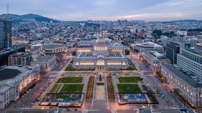
The Civic Center is home to San Francisco’s administration and several cultural institutions. The area was laid out and built after the earthquake in 1906, when, among other things, the city’s then town hall was destroyed.
The first buildings were completed in 1915, and throughout most of the 20th century the complex was continuously expanded with various institutions. In addition to the buildings mentioned, the state Supreme Court, the Supreme Court of California, the event building Bill Graham Civic Auditorium and the United Nations Plaza are also located here.
The Civic Center contains large open urban spaces, and with the Town Hall located here, the area has been the center of several demonstrations and political speeches; among others, Harvey Milk spoke here in the 1970s.
Centrally in the Civic Center there is a large square in front of the city’s town hall building, and from here there is a good view of both the town hall and most of the other buildings. This is also where you can see a number of flagpoles with historic American flags and other flags from famous battles, states or events. Here, for example, you can see the Grand Union Flag, which was the USA’s first official flag.
City Hall is San Francisco’s city hall, and it is also one of the city’s greatest architectural landmarks. The Beaux-Arts building was built in 1913-1915 as a replacement for the former City Hall, which was badly damaged in the 1906 earthquake.
It was a time when the City Beautiful Movement was a trend that made itself felt in many American cities, primarily in the country’s northeastern states. The movement’s starting point was an increasing population and a desire to build beautifully and often monumentally. The goal was to create beautiful urban areas and at the same time to increase morale in the city and create a higher quality of life for the citizens.
San Francisco City Hall is a good example of the result of the City Beautiful Movement, and the dimensions are impressive. The ground plane is 120×83 meters and the dome reaches a height of 93 meters, making it one of the tallest in the world.
Arthur Brown Jr. was an architect at the town hall. He designed the building design, but also details such as fonts and door handles. The central part of the building is the town hall rotunda, which is an impressive space under the large dome, which Arthur Brown, Jr. drawn with inspiration from Val-de-Grâce in Paris.
City Hall is open to visitors, and in addition to the building with the rotunda as the most visible, in the side wings you can also see elegant building designs and a small exhibition about the construction of San Francisco City Hall.
Over the years, many major events have taken place at the town hall. On November 27, 1978, the building entered the San Francisco history books when Mayor George Moscone and City Councilman Harvey Milk were murdered here. A slightly more enjoyable event occurred in 1954, when Marilyn Monroe and Joe DiMaggio were married at City Hall.

The Painted Ladies is an expression of painted houses in Victorian and Edwardian architecture, which were built from the mid-1800s to the beginning of the 1900s. The repainting, which is not in original decoration, took place from the 1960s, and today it says Painted Ladies in several places in San Francisco. In total, around 48,000 of these houses were built in the city; however, a number perished in the 1906 earthquake, and approximately 16,000 have been demolished.
The most famous of the so-called Painted Ladies are a series of six beautifully restored Victorian houses of the type that were very common in the 1800s. The six houses in Steiner Street were built from 1892 to 1896. The many new constructions were to cover the housing needs for the strong population growth in San Francisco at the time.
Many of the city’s Victorian houses were destroyed in the fire that followed the earthquake in 1906. The neighborhoods around Nob Hill were particularly affected, but in several parts of the city a number still remain, not least in Pacific Heights, the Western Addition, Fillmore and in the Haight.
Opposite The Painted Ladies in Steiner Street is Alamo Square Park, from which there is a fine view of both the ladies and other parts of San Francisco. Among other things, here is a view of the center of San Francisco with all the high-rise buildings and to the top of the Golden Gate Bridge.
The Ferry Building is the city’s ferry terminal for the many ferries that cross San Francisco Bay. It is therefore a good starting point for many tourists who want to take a closer look at the sights and cities around San Francisco.
The Ferry Building is also one of San Francisco’s most famous buildings. It was Arthur Page Brown who designed the building in 1892 in the Beaux-Arts style. The Ferry Building opened in 1898 and was a major traffic hub for traffic around the bay. This was not least the case before the opening of the Golden Gate Bridge to the north and the Oakland Bay Bridge to the east.
The monumental building stands beautifully close to the center of San Francisco. It is crowned by a central tower with a height of 75 meters. The tower is architecturally inspired by La Giralda tower in Seville, Spain, and below it there are arched arcades running the entire length of the Ferry Building.
For several years in the latter half of the 20th century, the Ferry Building was shielded from Market Street by an elevated highway. This is no longer the case and the building stands today as a visible fixed point at the eastern end of Market Street. The Ferry Building itself was reopened in 2003 after a major renovation, and since then there has been a market with shops and eateries here.
The Financial District is an area of the city that, as the name suggests, is home to insurance companies, banks, law firms, major corporations and other institutions in San Francisco. The district is located as a triangle in the city center between the streets Market Street in the south, Washington Street in the north and Kearny Street in the west.
The central street in the Financial District is Montgomery Street, which is also called the Wall Street of the West. Here and in the neighborhood’s other streets, the city’s modern skyscrapers lie side by side, and it is an exciting experience to take a walk in the area.
The view of the tall buildings is impressive from street level, and one should take a stroll along Montgomery Street. You can also see the area from above; for example from the top of the 210 meter high Bank of America Building (345 Montgomery Street) or from the Embarcadero Center’s Skydeck on Sacramento Street.
In many ways, the area’s history follows the development of the city of San Francisco. At the time, the Spanish colonial power was not interested in developing a city on the sandy lands here, and it was instead settlers who established themselves here from 1835. The first town plan was adopted in 1839, and since then the development has been rapid. Back then, the water line ran around Montgomery Street, but infill was chosen to expand both the area and the well-located port, which in many ways drove a large part of the city’s growth.
Skyscraper construction on the West Coast began in 1890 in San Francisco, where Michael Henry de Young built the 66-meter-tall Chronicle Building. Other skyscrapers were added, and they survived the great earthquake of 1906, which otherwise caused great destruction in the neighborhood. In the 1920s, the next row of high-rise buildings was built, and from the 1960s, high buildings were again built after height restrictions were changed.
After many protests, the city government reintroduced a ceiling on the height of new buildings in downtown San Francisco, and after the 1980s the development of new high-rise buildings moved to the so-called South Financial District, located south of Market Street.
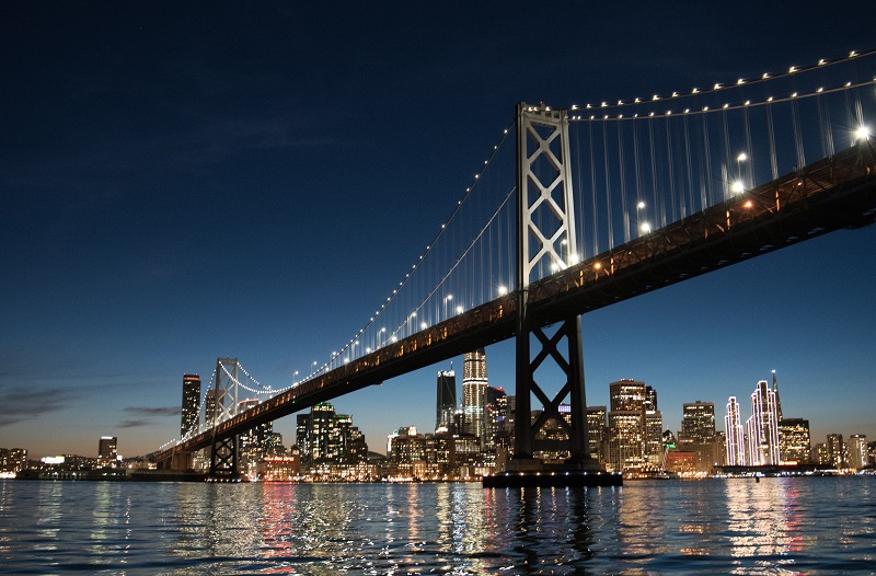
The colossal Oakland Bay Bridge is one of San Francisco’s two big, well-known bridges; the other is the Golden Gate Bridge. The Oakland Bay Bridge emanates from downtown San Francisco in the area immediately south of Market Street and the Ferry Building, offering magnificent views of the imposing bridge.
The Oakland Bay Bridge connects San Francisco with, among other things, the city of Oakland on the eastern shore of San Francisco Bay. The 14 kilometer long bridge connection crosses the island of Yerba Buena Island on the way across the bay.
The idea of a bridge across San Francisco Bay first arose during the gold rush of the mid-1800s, and a connection across the bay was proposed many times thereafter. However, it took until 1929 before the first concrete steps towards a bridge were taken, and after that things went fast. Construction began on 9 July 1933 and the bridge was inaugurated on 12 November 1936.
The Oakland Bay Bridge impresses with its dimensions. It was originally built as a combined car and rail bridge, but today it has been changed to a pure car bridge with two decks and five carriageways in each direction.
Of the total extent of the connection, it is especially the two bridge parts east and west of Yerba Buena Island that are structurally interesting. The bridge’s maximum span is 704 metres. The eastern bridge is 3,100 meters long with a clear passage under the bridge of 58 meters, while the western bridge is 2,800 meters long with a clear passage of 67 meters.
The bridge between San Francisco and Yerba Buena Island stars as the original two-deck suspension bridge. The bridge east of Yerba Buena Island has been rebuilt after the 1989 earthquake, when part of the upper bridge deck collapsed and fell onto the lower deck. During the reconstruction, a modern bridge was built with only one deck, which in turn became the world’s widest bridge when it opened in 2013.
San Francisco’s Museum of Modern Art opened its doors in 1935 as the first of its kind in the western United States. The current museum building was designed by Swiss architect Mario Botta and opened in 1995. The building is unique with its zebra-striped central section that rises from the red, modern fort-like structure.
The museum contains a fine collection within various themes such as architecture, design, photography, painting and sculpture. Among the many works, artists such as Paul Klee, Henri Matisse, Marcel Duchamp, Salvador Dali and Jackson Pollock are represented. In addition to the permanent collection at the museum, large and international changing exhibitions are also organized at the museum.
Grace Cathedral is an Anglican cathedral and at the same time one of the USA’s largest church buildings in the neo-Gothic style. Its history began with the first church in the parish, Grace Church, built in 1849. New and larger churches were built throughout the 19th century, and the third church was destroyed by the earthquake that leveled large parts of San Francisco in 1906.
Construction of the current cathedral began in 1928, but the majority of the building dates from the 1960s. The church was completed in 1964, and it is quite attractive on the outside and inside.
The cathedral was built with clear inspiration from Notre Dame in Paris and other large classical churches in France, including the beautiful rosette, which was made in fine glass mosaic. The entrance doors are adapted copies of 15th-century doors from Florence Cathedral’s baptistery; called the Gates of Paradise.
The interior of the church is impressive, and here you can see several fine works of art. In the floor you can see a labyrinth like the one in the cathedral in Chartres, France, and it is said that you reach a meditative state if you walk through the labyrinth’s corridors. You can also see a number of works by the artist Jan Henryk De Rosen, primarily from the 1930s-1940s.
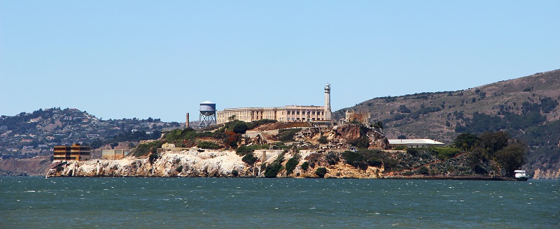
Alcatraz is the name of a rocky island located in the middle of San Francisco Bay. Today, the island is best known for its time as an isolated prison island, but there are also other parts of the area’s history that you can get to know on a trip here.
The island of Alcatraz Island became American with the USA’s takeover of California from Mexico in the 1800s. In 1850, President Millard Fillmore reserved Alcatraz for military purposes, and in the years 1853-1858, US engineer troops constructed several fortifications on the island as part of the defense of the entrance to San Francisco Bay.
During the American Civil War 1861-1865, Alcatraz was equipped with cannon positions, and from 1861 the island was used as a military prison due to the good location with cold and dangerous currents in the water around the rocks. The isolated island was deemed militarily unnecessary for the area’s defense shortly after the end of the Civil War, and instead was converted for continued use as a military prison.
In 1909-1912, a new large block of prison cells was built, and that building continues to dominate Alcatraz. It was a military prison, and prisoners of war were held on the island until 1946; even though Alcatraz was taken over by the United States Department of Justice in 1933 and established as a federal prison in 1934.
The first 137 federal prisoners arrived at Alcatraz on August 11, 1934. Most inmates on the island were hardened criminals such as murderers and bank robbers. Among the island’s prisoners during the prison years from 1934 to 1964 were Al Capone, George Machine Gun Kelly and Alvin Creepy Karpis. Officially, no one succeeded in escaping from Alcatraz during the 29 years. 36 prisoners tried to escape over time; 23 were captured and 8 others were shot or drowned during the escape. The last five are presumed to have drowned.
Alcatraz was an expensive prison to run compared to prisons elsewhere in the United States, and the salt water of the ocean had worn down buildings and facilities over the years. These were some of the reasons why Robert F. Kennedy ordered Alcatraz closed as a prison on March 21, 1963. The prisoners were moved from Alcatraz, and today Alcatraz Island is designated as a national monument and set up as a museum.
You can sail to the island from San Francisco and experience Alcatraz as a large museum that depicts the island’s deadly history through exciting exhibitions and with many objects. Among other things, you can see photographs, weapons, escape plans and the cells in which many of the island’s famous prisoners have been held.
Building-wise, you can see Alcatraz’s lighthouse, which was built in 1909. The tower is 26 meters high and is therefore only surpassed in height by the Alcatraz Water Tower; the water tower is 29 meters high. In the middle of the facility is the Main Cellhouse cell block, and around the island you can see some of the fortifications that were established in the 1800s.
The view from Alcatraz Island is quite spectacular. The island’s location in the middle of the entrance to San Francisco Bay provides a panoramic view of San Francisco and the city skyline, and you can clearly see the Golden Gate Bridge and the Oakland Bay Bridge on either side of the San Francisco Peninsula.
Sausalito is a cozy city on the San Francisco Bay that you can sail to from the Ferry Building or Fisherman’s Wharf or drive to by taking a trip over the Golden Gate Bridge. The city is a peaceful place with beautiful nature, parks, galleries, shops and lovely restaurants.
Miwok/Huimen Indians originally lived where Sausalito is today. The Europeans came here in 1775, but the Spanish chose to establish themselves south of the Golden Gate instead of in Sausalito, whose development only started in the first half of the 19th century.
William Richardson established the farm Rancho Saucelito, and there grew, among other things, a lot of fishing, but there was no real town until about 1870. The location was close to San Francisco, but the trip overland went all the way around San Francisco Bay.
In 1870, the town’s post office opened, and later in the same decade, the North Pacific Coast Railroad built a railroad here from the north, and Sausalito also got a regular ferry connection to San Francisco with the line. The city’s current spelling was adopted in 1887, and in 1893, Sausalito officially became a city.
Traffic over the Golden Gate grew, and beginning in 1926, Sausalito was connected to Hyde Street Pier in San Francisco by a car ferry service. The ferry operated as part of Highway 101, and Sausalito became one of the area’s traffic hubs with car ferries and more and more trains.
Traffic soon stopped with the opening of the Golden Gate Bridge in 1937. Car traffic was bypassed by the bridge, and car ferries and passenger trains closed in 1941. Passenger ferries continued and are still running.
Today, Sausalito is a popular excursion destination from San Francisco. Among other things, you can experience a cozy harbor environment with a marina and a number of houseboats, which Sausalito is known for. There are also a number of parks in the city, and immediately outside the city limits there is access to the Golden Gate National Recreation Area.
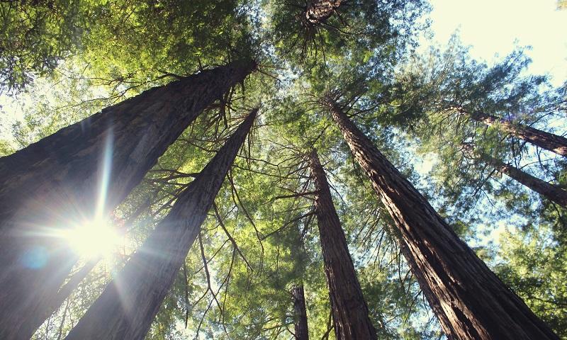
Muir Woods is a green area where, close to San Francisco, you can experience some of the world’s tallest trees; those are the Californian redwood trees. The trees used to stand along the entire Californian west coast, but in many places the original areas have been felled. John Muir Woods was spared the logging due to the isolated location of the area in relation to other and more accessible forests.
This type of redwood trees grow along the coast and take advantage of the fog that the Pacific often brings to the forests. The fog provides the necessary moisture for growth even in the dry Californian summer. The trees can grow up to 115 meters tall, but in Muir Woods the tallest reach around 80 meters. For the most part, the age is between 500 and 800 years, but there are trees that are over 1,200 years old.
On the east coast of San Francisco Bay lies the big city of Oakland, which is one of the USA’s busiest port cities. Oakland became a city in 1852, and today more than 400,000 people live in the city, which is connected to downtown San Francisco by the Oakland Bay Bridge and a railroad under San Francisco Bay.
There were the men Andrew Moon, Edson Adams and Horace Carpentier who in 1851 built the first in what was the beginning of Oakland the following year. There were less than 100 inhabitants living in the town at this time, where, among other things, two hotels, wharves and warehouse buildings had been established. In the following decades, the city grew with the construction of, for example, railways and port facilities. Before the year 1900, horse-drawn tram lines and later cable cars and electric trams had also been established in the city.
Oakland continued to grow in the 1900s. General Motors opened an automobile factory in the city in 1916, and 13 years later Chrysler also opened a plant here. The city’s downtown grew with many new and tall buildings such as the Tribune Tower from 1923 (409 13th Street). After World War II, construction continued, including the Kaiser Corporation’s office building, Kaiser Center (300 Lakeside Drive), at 118 meters in height.
For tourists in San Francisco, the trip to Oakland is short and there are several things to experience here. Architecturally, the Tribune Tower is Oakland’s landmark, while there is also a very vibrant arts scene and many bars and restaurants in several of the city’s neighborhoods to enjoy.
In downtown, you can take a walk to see the Tribune Tower and the neighborhood’s other noteworthy buildings. These are, for example, the town hall Oakland City Hall (1 Frank H. Ogawa Plaza) from 1917, the Fox Oakland Theater (1807 Telegraph Avenue) from 1928 and the Paramount Theater (2025 Broadway) from 1931.
The Civic Center is home to San Francisco’s administration and several cultural institutions. The area was laid out and built after the earthquake in 1906, when, among other things, the city’s then town hall was destroyed.
The first buildings were completed in 1915, and throughout most of the 20th century the complex was continuously expanded with various institutions. In addition to the buildings mentioned, the state Supreme Court, the Supreme Court of California, the event building Bill Graham Civic Auditorium and the United Nations Plaza are also located here.
The Civic Center contains large open urban spaces, and with the Town Hall located here, the area has been the center of several demonstrations and political speeches; among others, Harvey Milk spoke here in the 1970s.
Centrally in the Civic Center there is a large square in front of the city’s town hall building, and from here there is a good view of both the town hall and most of the other buildings. This is also where you can see a number of flagpoles with historic American flags and other flags from famous battles, states or events. Here, for example, you can see the Grand Union Flag, which was the USA’s first official flag.
City Hall is San Francisco’s city hall, and it is also one of the city’s greatest architectural landmarks. The Beaux-Arts building was built in 1913-1915 as a replacement for the former City Hall, which was badly damaged in the 1906 earthquake.
It was a time when the City Beautiful Movement was a trend that made itself felt in many American cities, primarily in the country’s northeastern states. The movement’s starting point was an increasing population and a desire to build beautifully and often monumentally. The goal was to create beautiful urban areas and at the same time to increase morale in the city and create a higher quality of life for the citizens.
San Francisco City Hall is a good example of the result of the City Beautiful Movement, and the dimensions are impressive. The ground plane is 120×83 meters and the dome reaches a height of 93 meters, making it one of the tallest in the world.
Arthur Brown Jr. was an architect at the town hall. He designed the building design, but also details such as fonts and door handles. The central part of the building is the town hall rotunda, which is an impressive space under the large dome, which Arthur Brown, Jr. drawn with inspiration from Val-de-Grâce in Paris.
City Hall is open to visitors, and in addition to the building with the rotunda as the most visible, in the side wings you can also see elegant building designs and a small exhibition about the construction of San Francisco City Hall.
Over the years, many major events have taken place at the town hall. On November 27, 1978, the building entered the San Francisco history books when Mayor George Moscone and City Councilman Harvey Milk were murdered here. A slightly more enjoyable event occurred in 1954, when Marilyn Monroe and Joe DiMaggio were married at City Hall.
The Painted Ladies is an expression of painted houses in Victorian and Edwardian architecture, which were built from the mid-1800s to the beginning of the 1900s. The repainting, which is not in original decoration, took place from the 1960s, and today it says Painted Ladies in several places in San Francisco. In total, around 48,000 of these houses were built in the city; however, a number perished in the 1906 earthquake, and approximately 16,000 have been demolished.
The most famous of the so-called Painted Ladies are a series of six beautifully restored Victorian houses of the type that were very common in the 1800s. The six houses in Steiner Street were built from 1892 to 1896. The many new constructions were to cover the housing needs for the strong population growth in San Francisco at the time.
Many of the city’s Victorian houses were destroyed in the fire that followed the earthquake in 1906. The neighborhoods around Nob Hill were particularly affected, but in several parts of the city a number still remain, not least in Pacific Heights, the Western Addition, Fillmore and in the Haight.
Opposite The Painted Ladies in Steiner Street is Alamo Square Park, from which there is a fine view of both the ladies and other parts of San Francisco. Among other things, here is a view of the center of San Francisco with all the high-rise buildings and to the top of the Golden Gate Bridge.
The Ferry Building is the city’s ferry terminal for the many ferries that cross San Francisco Bay. It is therefore a good starting point for many tourists who want to take a closer look at the sights and cities around San Francisco.
The Ferry Building is also one of San Francisco’s most famous buildings. It was Arthur Page Brown who designed the building in 1892 in the Beaux-Arts style. The Ferry Building opened in 1898 and was a major traffic hub for traffic around the bay. This was not least the case before the opening of the Golden Gate Bridge to the north and the Oakland Bay Bridge to the east.
The monumental building stands beautifully close to the center of San Francisco. It is crowned by a central tower with a height of 75 meters. The tower is architecturally inspired by La Giralda tower in Seville, Spain, and below it there are arched arcades running the entire length of the Ferry Building.
For several years in the latter half of the 20th century, the Ferry Building was shielded from Market Street by an elevated highway. This is no longer the case and the building stands today as a visible fixed point at the eastern end of Market Street. The Ferry Building itself was reopened in 2003 after a major renovation, and since then there has been a market with shops and eateries here.
The Financial District is an area of the city that, as the name suggests, is home to insurance companies, banks, law firms, major corporations and other institutions in San Francisco. The district is located as a triangle in the city center between the streets Market Street in the south, Washington Street in the north and Kearny Street in the west.
The central street in the Financial District is Montgomery Street, which is also called the Wall Street of the West. Here and in the neighborhood’s other streets, the city’s modern skyscrapers lie side by side, and it is an exciting experience to take a walk in the area.
The view of the tall buildings is impressive from street level, and one should take a stroll along Montgomery Street. You can also see the area from above; for example from the top of the 210 meter high Bank of America Building (345 Montgomery Street) or from the Embarcadero Center’s Skydeck on Sacramento Street.
In many ways, the area’s history follows the development of the city of San Francisco. At the time, the Spanish colonial power was not interested in developing a city on the sandy lands here, and it was instead settlers who established themselves here from 1835. The first town plan was adopted in 1839, and since then the development has been rapid. Back then, the water line ran around Montgomery Street, but infill was chosen to expand both the area and the well-located port, which in many ways drove a large part of the city’s growth.
Skyscraper construction on the West Coast began in 1890 in San Francisco, where Michael Henry de Young built the 66-meter-tall Chronicle Building. Other skyscrapers were added, and they survived the great earthquake of 1906, which otherwise caused great destruction in the neighborhood. In the 1920s, the next row of high-rise buildings was built, and from the 1960s, high buildings were again built after height restrictions were changed.
After many protests, the city government reintroduced a ceiling on the height of new buildings in downtown San Francisco, and after the 1980s the development of new high-rise buildings moved to the so-called South Financial District, located south of Market Street.
The colossal Oakland Bay Bridge is one of San Francisco’s two big, well-known bridges; the other is the Golden Gate Bridge. The Oakland Bay Bridge emanates from downtown San Francisco in the area immediately south of Market Street and the Ferry Building, offering magnificent views of the imposing bridge.
The Oakland Bay Bridge connects San Francisco with, among other things, the city of Oakland on the eastern shore of San Francisco Bay. The 14 kilometer long bridge connection crosses the island of Yerba Buena Island on the way across the bay.
The idea of a bridge across San Francisco Bay first arose during the gold rush of the mid-1800s, and a connection across the bay was proposed many times thereafter. However, it took until 1929 before the first concrete steps towards a bridge were taken, and after that things went fast. Construction began on 9 July 1933 and the bridge was inaugurated on 12 November 1936.
The Oakland Bay Bridge impresses with its dimensions. It was originally built as a combined car and rail bridge, but today it has been changed to a pure car bridge with two decks and five carriageways in each direction.
Of the total extent of the connection, it is especially the two bridge parts east and west of Yerba Buena Island that are structurally interesting. The bridge’s maximum span is 704 metres. The eastern bridge is 3,100 meters long with a clear passage under the bridge of 58 meters, while the western bridge is 2,800 meters long with a clear passage of 67 meters.
The bridge between San Francisco and Yerba Buena Island stars as the original two-deck suspension bridge. The bridge east of Yerba Buena Island has been rebuilt after the 1989 earthquake, when part of the upper bridge deck collapsed and fell onto the lower deck. During the reconstruction, a modern bridge was built with only one deck, which in turn became the world’s widest bridge when it opened in 2013.
San Francisco’s Museum of Modern Art opened its doors in 1935 as the first of its kind in the western United States. The current museum building was designed by Swiss architect Mario Botta and opened in 1995. The building is unique with its zebra-striped central section that rises from the red, modern fort-like structure.
The museum contains a fine collection within various themes such as architecture, design, photography, painting and sculpture. Among the many works, artists such as Paul Klee, Henri Matisse, Marcel Duchamp, Salvador Dali and Jackson Pollock are represented. In addition to the permanent collection at the museum, large and international changing exhibitions are also organized at the museum.
Grace Cathedral is an Anglican cathedral and at the same time one of the USA’s largest church buildings in the neo-Gothic style. Its history began with the first church in the parish, Grace Church, built in 1849. New and larger churches were built throughout the 19th century, and the third church was destroyed by the earthquake that leveled large parts of San Francisco in 1906.
Construction of the current cathedral began in 1928, but the majority of the building dates from the 1960s. The church was completed in 1964, and it is quite attractive on the outside and inside.
The cathedral was built with clear inspiration from Notre Dame in Paris and other large classical churches in France, including the beautiful rosette, which was made in fine glass mosaic. The entrance doors are adapted copies of 15th-century doors from Florence Cathedral’s baptistery; called the Gates of Paradise.
The interior of the church is impressive, and here you can see several fine works of art. In the floor you can see a labyrinth like the one in the cathedral in Chartres, France, and it is said that you reach a meditative state if you walk through the labyrinth’s corridors. You can also see a number of works by the artist Jan Henryk De Rosen, primarily from the 1930s-1940s.


