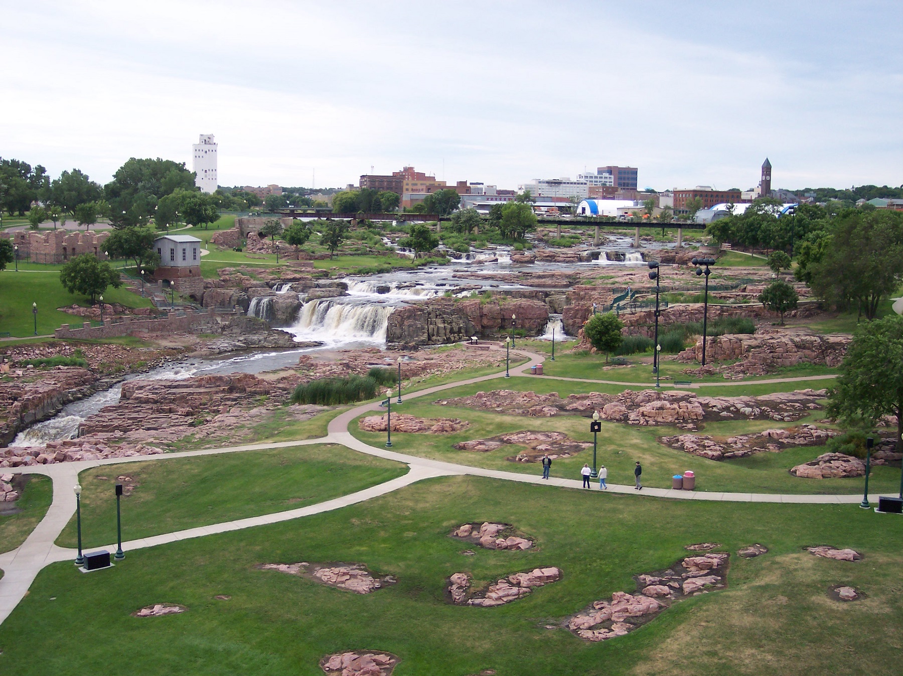
Loading

Bismarck

46.80416, -100.78776

Bismarck Travel Guide

Travel Author

Stig Albeck

City Map

City Introduction

Bismarck is the capital of the US state of North Dakota. The city’s history began in 1872, when it was founded by settlers on the banks of the Missouri River. The new town was called Missouri Crossing, which thus marked the place where the famous Lewis and Expedition had crossed the great river in the years 1804-1806. Later, the Missouri Crossing was called Edwinton after Edwin Ferry Johnson, who was chief engineer of the Northern Pacific Railway, which expanded the railroads in North Dakota.

In 1873 the railway company renamed Edwinton Bismarck after German Chancellor Otto von Bismarck in the hope of attracting German settlers and German investment in the railway company. In 1883, Bismarck became the capital of the Dakota Territory, which became a US state in 1889. Since then, Bismarck has grown to be the state’s second largest city after Fargo.

Today, Bismarck is a modern city, where in several places in the downtown you can see some sights that lead back to the city’s early history. Downtown is located on the streets north and northwest of the Bismarck Depot, which was built by the Northern Pacific Railway in 1900 in Spanish-inspired architecture. From here you can walk west on Main Avenue to the Camp Hancock State Historic Site. Camp Hancock was established as a garrison in 1872 to protect the construction of the railroad through the area, which took place 1872-1877.

Today, Camp Hancock is designated as a historic site, and you can see the Bread of Life Church from 1881, which was moved to here in 1965. In the downtown streets, you can also see buildings such as the World War Memorial Building and the former McKenzie Hotel, located opposite the railway station. The hotel opened in 1911 and was the city’s leading hotel throughout the 20th century with guests such as Theodore Roosevelt, Calvin Coolidge, John F. Kennedy and Lyndon Johnson.

On the periphery of downtown there are other interesting buildings. You can see, for example, the Cathedral of the Holy Spirit, which was built 1941-1945 in elegant art deco architecture as the city’s Catholic cathedral. There are many fine details in the decoration of the church, such as the stained-glass windows. If you walk east from the cathedral along Avenue B, you come to Trinity Lutheran Cathedral and St. George’s Episcopal Memorial Church, noted for its stained-glass windows, partly derived from English churches destroyed during WWII German bombing.

The former governor’s residence of North Dakota’s governor is close to the two churches. The fine house was built in 1884 by Asa Fisher as a private residence, and it was the governor’s residence from 1893 to 1960. The house is now open as a museum and furnished like in the early years as the governor’s residence.

In Bismarck you can also see the North Dakota State Capitol, which is the government building of the state of North Dakota. The Capitol was built in art deco in the years 1931-1934 as the state’s tallest building, and the 73-metre-high office tower was called the skyscraper of the prairie. In addition to the central tower, there are also other buildings in the complex around the Capitol, such as the neoclassical Liberty Memorial Building from 1924 and the residence of North Dakota’s governor.

Southeast of the Capitol, you can visit the North Dakota Heritage Center, which is the state of North Dakota’s museum of history. In the museum’s interesting exhibitions, North Dakota’s history and cultures are explained, and the collections include, among many other things, finds of dinosaurs and a skeleton of a mastodon.

Top Attractions

Camp Hancock State Historic Site

Camp Hancock was established in 1872 as one of several military installations along the northern section of the Northern Pacific Railway, which was then under construction. Its purpose was to protect railroad workers and secure the transportation corridor that connected the Missouri Valley with the western territories. The facility was not a full-scale fort, but a military post consisting of barracks, officers’ quarters, workshops, and a small parade ground. The original buildings were constructed of wood with simple foundations adapted to the terrain west of the Missouri River. The buildings were located around an open space, and their location reflected the temporary nature of the army unit and the need for rapid construction during the expansion of the railroad.

During the 1870s, Camp Hancock developed into a central supply post for military patrols and engineering units operating in the region. The post housed, among other things, a signal station area and a telegraph station, which provided an important link between the civil authorities of the territory and the military units in the Dakota Territory. The supply of materials was mainly via the railway, and the logistics of the post were organised around the track areas, where magazines and storage rooms were directly related to the transport line. This created a working landscape where military and civilian functions mixed, and where the role of the post gradually changed from pure military security to administrative and logistical support.

One of the most striking buildings that was built was a small wooden church. Today, the Church of the Bread of Life can be seen on the site. It was initially built elsewhere in the city and moved here in 1965. The church was first consecrated in 1880 and has thus been preserved as one of the oldest standing buildings in the area. The interior originally had no permanent installations, but was later adapted for congregational use with rows of benches and a small choir. Today, the building represents an important physical trace of the early settlement that arose in connection with military posts and the railway.

After the closure of Camp Hancock as an active military post, the area gradually transitioned to civilian functions as Bismarck developed into the administrative center of the Dakota Territory. Several of the military buildings were removed or rebuilt, while others fell into disrepair and disappeared altogether. In the early 20th century, the remains of the facility were designated a historic site, and archaeological investigations documented the locations of the earlier buildings and structures such as stockade sections, trails, and foundations from workshop buildings. Today, the site serves as an open-air museum with some preserved and reconstructed buildings and artifacts.


Church of the Bread of Life

The Church of the Bread of Life is a church built in the 1870s and dedicated in 1880. The church was built for the early community that emerged and developed into the expanding urban area that became Bismarck. The building was constructed of brick with a classic rectangular floor plan and a high gable roof that marks the church’s main nave.

Inside, you can experience a beautiful and simple church room. The church’s interior also includes an organ, some stained glass windows, and lighting, which was originally lit by candles and later by electric light. The function of the church expanded over time, as did the buildings in the church complex.

The Church of the Bread of Life was originally built at the intersection of Avenue A and Mandan Street. It was moved to a new location around 1900, and it was at this location that the church was expanded to include, among other things, a congregation building. The church was later donated to the state, and since 1965 it has stood on the Camp Hancock State Historic Site.


Bismarck Depot

Built in 1900 as a railroad depot for the Northern Pacific Railway, Bismarck Depot served as a major hub for both freight and passenger transportation in central North Dakota. The building was constructed of brick with classical proportions and details inspired by the Romanesque Revival style, with arched windows and cornices that accentuate the facade elements. The floor plan included central waiting rooms, ticket offices, and a baggage room at the rear.

The old station stands beautifully in the streetscape as a symbol of Bismarck’s early growth period. Today, it serves as a cultural and visitor center, where the history of the Northern Pacific Railway and the role of the railroad in the development of Bismarck is conveyed. The architecture and rooms are used for exhibitions and meetings, among other things, allowing visitors to experience diverse culture along with the original structure of the building.


Patterson Hotel

First known as the McKenzie Hotel, the Patterson Hotel was built in the early 20th century as one of Bismarck’s first major hotels. It opened in 1911 and served as a gathering place for travelers, business people, and local residents. The building was built of brick, an imposing structure across from the Bismarck Depot, where travelers arrived in the city.

Inside, the hotel’s floor plan was divided into a foyer, lobby, reception area, and stairwell, which provided access to the rooms on the upper floors. The lobby originally had high ceilings, tile or wood floors, and detailed paneling, creating a formal and inviting space for guests. Dining and meeting rooms were located adjacent to the lobby and were used for both formal events, business meetings, and social gatherings.

The McKenzie Hotel changed its name to the Patterson Hotel and served as a social and commercial center in Bismarck for several decades. The building illustrates how early hotels in the northern Great Plains were constructed. It originally had six stories, but was expanded over the decades to have ten stories. This was due in part to the fact that at the time, taxes were not payable on buildings that were still under construction.

As the city’s leading hotel, many celebrities stayed here over the years. This included presidents Theodore Roosevelt, Calvin Coolidge, John F. Kennedy and Lyndon Johnson. The hotel closed in the 1970s, not least due to the construction of highways that led around the city instead of through it. The hotel was then converted into residential accommodation, but you can visit it in the restaurant on the ground floor.


World War Memorial Building

The World War Memorial Building was built in Bismarck as a memorial to local soldiers who participated in World War I, and was later expanded to include memorials from other conflicts. The building was built in the classicist style, and it was built for various purposes such as offices, a meeting room, an exhibition hall and a memorial hall.

Inside, the building is organized around a large hall with a high ceiling and an open plan, where the walls and floors are made of granite and marble to signal permanence and respect. The memorial hall contains inscriptions, statues and plaques with the names of the fallen soldiers, as well as symbolic elements such as flagpoles and decorative light installations. The layout is designed for ceremonial movement, allowing visitors to walk through the hall focusing on the central monumental elements.


George’s Episcopal Memorial Church

St. George’s Episcopal Memorial Church traces its roots back to 1873, when the first Protestant service in Bismarck was held by Episcopalian Reverend Charles Swift. In 1878, the first permanent missionary arrived, and the following year the congregation began working toward building their own church. The first church, originally called the Church of the Bread of Life, was built on land donated by the Northern Pacific Railroad six lots outside the city center. The building was erected between 1879 and 1880 by John Hoagland and was based on a design by British architect HenryG. Harrison with local adaptations by A.E. Hussey. The style was inspired by Gothic Revival, and the church was given a tower with a bell that came from the steamship Red Cloud that had sunk in the Missouri River.

In 1890, the church building was renamed St. George’s Episcopal Church, and around 1900 the first building was moved to a corner at Third Street and Rosser Avenue. The interior had been decorated with warm colors and symbolism during a renovation in 1887. The walls were painted in several shades of terra cotta with vine stencils, while the ceiling was painted sky blue with light lime ornamentation. The original church served as the congregation’s home for many years until the congregation grew and the need for a larger, modern church building became apparent.

The current St. George’s Episcopal Memorial Church was built in the years following World War II, and the new building was dedicated in 1949. The architect was Herman M. Leonhard, who based the design on Cass Gilbert’s St. John the Divine Episcopal Church in Moorhead but adapted it to the Bismarck context. The new church is built of concrete, and one of the most striking features of the new church is its stained glass windows, made by Barton, Kinder & Alderson of Brighton, England. Many of the windows contain pieces of glass that came from British churches that were bombed during World War II. Some of the glass can be traced back to the Middle Ages.


Former Governors’ Mansion

Located at 320 East Avenue B in Bismarck, the Former Governors’ Mansion is a historical museum managed by the North Dakota State Historical Society. The house was originally built in 1884 as the private residence of Asa Fisher, a prominent city businessman involved in banking, railroads, and retail. The architecture is typical Victorian stick style, with wood paneling, decorative cornices, and elements reminiscent of European wooden buildings, combined with the sturdy materials and design lines popular in Bismarck at the time.

In 1893, the state purchased the house for $5,000 to use as the governor’s residence. It served as the home of governors from Eli Shortridge until 1960, when the last governor moved to a new residence at the Capitol Building. During this period, a total of 20 governors lived in the house, and the house was used for both formal and private purposes, as reflected in the layout of the rooms, with a reception, parlor, dining room, and offices on the ground floor and private bedrooms upstairs.

After 1960, the house was converted into a clinic, and later used as office space for the North Dakota Department of Health. In 1975, the property was transferred to the State Historical Society for the purpose of preserving it as a historic house museum. The restoration included both the exterior and interior. The facade was restored to its 1893 appearance, and inside, walls and wallpaper were exposed so that visitors can see layers of historic color and pattern.


Cathedral of the Holy Spirit

The Cathedral of the Holy Spirit was built in the years 1941-1945 as the cathedral of the Catholic Diocese of Bismarck, and it constitutes the city’s main church for this faith in both religious and architectural significance. The building was constructed of concrete in the modern Art Deco architecture of the time, giving a sky-high expression, which is manifested in the slender church tower.

The interior contains a large and open church room, which matches the exterior lines of the church. Natural light flows into the room through the two rows of stained glass windows. Around the church there is a residence for the bishop of the diocese and a school building. The residence was designed in Art Deco corresponding to the style of the church, and the school was built and inaugurated in 1951.


North Dakota State Capitol

The North Dakota State Capitol was built between 1932 and 1934 to replace the previous capitol building that had been destroyed by fire. The architecture is an example of Art Deco-inspired high-rise design used in a state administrative building, and the structure is markedly different from the classic domed capitols of most other states in the United States. The building consists of a 21-story main tower structure and a lower wing, where legislative chambers and miscellaneous functions are located. The construction was made of steel and reinforced concrete with cladding in light limestone panels, giving the building a uniform vertical appearance.

The legislative wing consists of large, rectangular chambers with high panel walls and acoustic ceilings, which were developed for parliamentary use at a time when microphones and speakers were not yet standardized. The room is finished in dark wood, while the wall surfaces in the foyer use light stone materials and geometric ornaments, representing the Art Deco style’s focus on strict lines and simplified patterns. Construction of the Capitol took place during the Depression and was carried out under strict budget constraints, which led to a number of technical solutions that reduced costs without changing functional requirements. These included modular office floors, standardized door and window frames, and the use of machined metal panels in the interior.

The tower was equipped with an observation area on the top floor, from which one could orient oneself in the open landscape surrounding the Missouri River and the prairie to the north and east. These views were part of the original function, where the building was to serve as both an administrative center and a visual landmark. During the 20th century, the North Dakota State Capitol underwent several expansions, such as a new administration wing. The large park surrounding the building was expanded with monuments and ceremonial squares, and the facility is now part of a larger administrative district with several public buildings. The Capitol continues to serve as the center of the legislative and executive branches of the state and is one of the most distinctive capitol buildings in the United States due to its Art Deco architecture.


North Dakota Heritage Center & State Museum

Located in the heart of Bismarck’s Capitol grounds, the North Dakota Heritage Center & State Museum serves as the state’s primary museum and archive of cultural history. The building is comprised of several interconnected sections that house exhibit halls, research laboratories, archival spaces, and educational facilities. Visitors can follow a chronological journey through the state’s history from geological formations, fossils, and indigenous cultures to European colonization and modern society.

Exhibits include permanent collections documenting geology, paleontology, Native culture, and European settlement. Large panels and glass cases feature artifacts such as tools, clothing, weapons, and household items from the 18th and 19th centuries. Several sections are dedicated to the interaction between nature and humans, and exhibits feature detailed models of river systems, agricultural development, and transportation infrastructure.

Other Attractions

Day Trips

Fort Abraham Lincoln State Park

Fort Abraham Lincoln State Park was established as a military post in 1872 to protect the Northern Pacific Railway’s expansion and surrounding settlements. The fort became known as the home of the 7th Cavalry Regiment under General George Armstrong Custer and served as a logistical and operational hub in the Dakota Territory. The post consisted of officers’ quarters, barracks, stables, magazine buildings, and a parade ground, all located within a palisade-lined area. The buildings were primarily constructed of wood with foundations and joists adapted to the floodplain soil.

The fort’s internal organization centered around the parade ground, where training and ceremonial activities took place. The barracks were used as living quarters for soldiers, and the officers’ quarters were located close to the parade ground to provide both overview and control. The stables housed horses, which were essential for patrols and transportation, while the storehouses provided storage for provisions, ammunition, and tools. Logistics were adapted to the river and railroad transportation options, making the post a central element of both military and civilian infrastructure.

The park now includes reconstructed buildings that show the fort’s original layout and function. Visitors can walk through the officers’ quarters, barracks, and parade ground and see how the military structures were organized for both practical and ceremonial purposes. There are also exhibits documenting the daily lives of soldiers, military operations, interactions with Native tribes, and the post’s role in the development of the area.


On-a-Slant Village

On-a-Slant Village was a Hidatsa Indian village located along the Missouri River in the area that is now near Fort Abraham Lincoln State Park. The village existed from the late 18th century to the mid-19th century and served as a central residential and trading center for the Hidatsa people. The dwellings consisted of earthen huts, which were half-buried to provide insulation from the climate, and were arranged in circular or rectangular groups that created communal courtyards. The village also had separate areas for storage, ceremonies, and trade, demonstrating a complex social and economic system.

The work of reconstructing and documenting On-a-Slant Village has revealed extensive archaeological finds of pottery, tools, house foundations, and waste layers that provide detailed information about daily life, diet, and trade. The village’s location near the Missouri River provided access to transportation, fishing, and agriculture, while trade contacts with European and American traders enabled the exchange of goods such as metals, clothing, and household utensils.

Today, visitors can see marked foundations, information signs, and reconstructions of earthen huts that illustrate the original layout of the village. Trails through the area show the location of central buildings and communal areas, and installations tell the story of the Hidatsa people’s social structure, rituals, and trade relations. The landscape has been preserved in a way that provides a clear picture of the village’s orientation in relation to the river, soil, and natural resources.

Historically, On-a-Slant Village documents the precolonial and early colonial settlement history of Dakota Territory. The village shows how indigenous cultures organized settlements, utilized natural resources, and established trading systems that were influenced by European contact. Today, the area serves as both an archaeological site and a learning center where visitors can learn about the Hidatsa people’s way of life, culture, and relationships to early American expansion.


Medora

Medora is a historic town in western North Dakota that emerged in the late 1800s as a trading and service center for settlers, ranchers, and railroad projects in the Badlands region. The town’s origins are closely linked to the Marquis de Morés, who established a ranch and meat processing plant in the area. The town grew rapidly as a supply point, and hotels, stores, stables, workshops, and private residences were built. The town’s street plan reflects both its convenient location in relation to the Missouri River and railroad and the developers’ need for commercial and social centers in a sparsely populated area.

The architecture of Medora features a combination of wood and brick buildings, representing both businesses and residences. Hotels often have multi-story facades with large windows facing the street, while stores and workshops are lower. Many buildings have been preserved or restored, giving a clear picture of the town’s original layout and function. Medora’s layout and building massing demonstrate how small settlements could serve as hubs for trade, transportation, and social activity in the western Dakota Territory.

The town has historical significance as the gateway to Theodore Roosevelt National Park and as the cultural center of the Badlands region. Medora has maintained its role as a tourist destination through museums, historic buildings, theaters, and cultural events. Visitors can experience guided tours, historical demonstrations, rodeos, musical performances, and exhibits about the history of the settlers and the Marquis de Morés. These activities create a living connection between history and modern culture.


Theodore Roosevelt National Park

Theodore Roosevelt National Park was established to preserve the unique geology, flora, and fauna of western North Dakota, where prairie, badlands, and floodplains dominate the landscape. The park is divided into three units: the North Unit, the South Unit, and the Elkhorn Ranch Unit. The landscape consists of deep canyons, steep slopes, grasslands, and scattered woodlands. The variation in soil and river erosion have created dramatic formations that served as both natural barriers and resources for Native peoples and early settlers. The park was named in honor of Theodore Roosevelt, whose experiences as a rancher and conservationist in the area inspired his later work in conservation and national parks.

The park’s wildlife includes bison, prairie dogs, moles, deer, and many species of birds. The ecosystem supports complex food webs and variations between grasslands and cliffs. The park has established trails and scenic drives that provide visitors with access to key areas. Visitor centers and information stations offer both historical and natural science exhibits that document the wildlife, geology, climate, and the area’s importance to Native cultures and European settlers.

The park’s landscaping and infrastructure are designed to combine conservation and public access. Trails, overlooks, and campgrounds are located to reduce erosion and habitat disturbance. Some of the park’s historic sites, such as Elkhorn Ranch, showcase Theodore Roosevelt’s settlement and ranching. Buildings and foundations from the ranch have been preserved as examples of practical construction techniques, agricultural history, and adaptation to the harsh environment of the Dakota Territory.


Fort Union Trading Post National Historic Site

The Fort Union Trading Post National Historic Site was established in the early 1800s as one of the most important trading posts along the Upper Missouri River. The fort served as a hub for trade between European and American fur traders and indigenous tribes, including the Hidatsa, Mandan, and Arikara. The building and grounds included warehouses, trading offices, residences, stables, and palisades that organized the activity both functionally and defensively. The construction was primarily wood with earth foundations, ensuring rapid construction and adaptation to the river’s flooding.

The trading post was divided into sections for merchandise, residences, and ceremonial functions. Warehouses were used to store furs, metals, and trade goods, while offices and residences were centrally located for control and administration. The fort’s location on the Missouri River provided easy access to transportation by boat, and the river’s bends and gentle banks were utilized for both loading and unloading. The layout of the buildings and palisades shows how trade, security, and daily life were organized in the strategically important area.

Today, visitors can see reconstructed warehouses, trading huts, stables, and palisades that reflect the original layout of the fort. Exhibits document trade networks, daily life, relationships with indigenous peoples, and European-American interaction. Trails and information boards show how the buildings were organized and how the river was used for both transportation and defense. The reconstructions provide a concrete picture of the logistical and social systems that were necessary for trade and survival in the area.


Pierre, South Dakota, United States, USA

Pierre

Pierre is the picturesque capital city of South Dakota. It is located along the banks of the Missouri River, and it’s history dates back to 1880 when it was founded on the east bank of the river, opposite Fort Pierre. The fort and the city was named after Pierre Chouteau Jr., who was a prominent fur trader. The city grew and became a center for trade and transportation. South Dakota was admitted as a state in 1889, and Pierre was chosen as the state capital due to its central location. It has developed ever since, and Pierre is today home to both historical landmarks and modern buildings.

The most iconic landmark in Pierre is the impressive South Dakota State Capitol. It was completed in 1910, and the grand building features a blend of Classical Revival and Renaissance Revival architectural styles. The Capitol’s great dome and beautifully landscaped grounds are great sights, including the Flaming Fountain veterans’ memorial. Inside, you can admire murals and sculptures in the central rotunda.

Read more about Pierre


Fargo, North Dakota, United States, USA

Fargo

Fargo in North Dakota is a city with an interesting history and great sights. Founded in 1871, Fargo began as a small settlement where the Northern Pacific Railroad crossed the Red River. It was named after William G. Fargo, a director of the Northern Pacific Railroad and co-founder of Wells Fargo Express Company.

Hereafter the city quickly grew from a rough frontier town into a bustling hub of commerce and industry. By the end of the 1800s, Fargo had established itself as a centre in the region, attracting settlers with the promise of fertile farmland in the Red River Valley.

Read more about Fargo


Winnipeg, Canada

Winnipeg

Winnipeg is the capital and largest city of Manitoba, which along with Alberta and Saskatchewan are Canada’s prairie provinces. As the administrative center you can see the provincial government buildings in the city, which also has many other sights.

In architectural and cultural history, Winnipeg ranges from the city’s early years and constructions to modern buildings. The beginning of the 20th century is represented by Manitoba Club and Fort Garry Hotel, while the Canadian Museum of Human Rights stands as one of the city’s newer monuments of architecture.

Read more about Winnipeg


Billings, Montana, USA

Billings

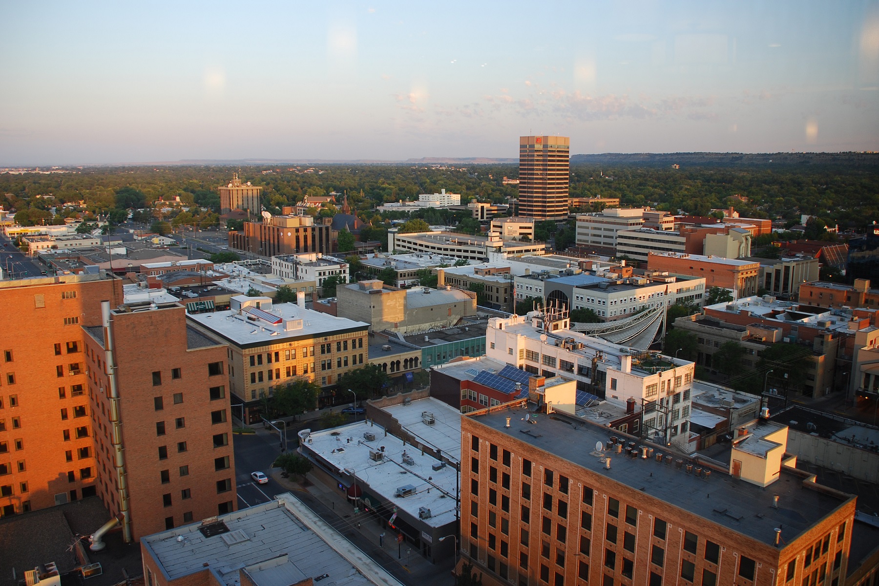
Billings is the largest city in the US state of Montana. The city is set in the Yellowstone Valley, which was settled and developed in the late 19th century. In 1877, settlers established Coulson as the first town, and it was then a lawless place. When the railroad came to the area, the railroad owned land west of Coulson, and the company established Billings as a railroad town in 1882, naming it after Frederick H. Billings, president of the Northern Pacific Railways 1879-1881.

At first there were three buildings here, but in a few months 2,000 had settled in the new town. Some of the settlers came from Coulson, which as a town disappeared in the 1930s. By 1910, Billings had more than 10,000 residents, and growth continued throughout the century. The city became the center of energy production after the discovery of oil and gas in Montana and Wyoming, and later many high-rise buildings were built from the 1970s and 1980s.

Read more about Billings

Geolocation

In short

Bismarck, North Dakota Bismarck, North Dakota[/caption]

Overview of Bismarck

Bismarck is the capital of the US state of North Dakota. The city’s history began in 1872, when it was founded by settlers on the banks of the Missouri River. The new town was called Missouri Crossing, which thus marked the place where the famous Lewis and Expedition had crossed the great river in the years 1804-1806. Later, the Missouri Crossing was called Edwinton after Edwin Ferry Johnson, who was chief engineer of the Northern Pacific Railway, which expanded the railroads in North Dakota.

In 1873 the railway company renamed Edwinton Bismarck after German Chancellor Otto von Bismarck in the hope of attracting German settlers and German investment in the railway company. In 1883, Bismarck became the capital of the Dakota Territory, which became a US state in 1889. Since then, Bismarck has grown to be the state’s second largest city after Fargo.

Today, Bismarck is a modern city, where in several places in the downtown you can see some sights that lead back to the city’s early history. Downtown is located on the streets north and northwest of the Bismarck Depot, which was built by the Northern Pacific Railway in 1900 in Spanish-inspired architecture. From here you can walk west on Main Avenue to the Camp Hancock State Historic Site. Camp Hancock was established as a garrison in 1872 to protect the construction of the railroad through the area, which took place 1872-1877.

About the Bismarck travel guide

Contents: Tours in the city + tours in the surrounding area
Published: Released soon
Author: Stig Albeck
Publisher: Vamados.com
Language: English

About the travel guide

The Bismarck travel guide gives you an overview of the sights and activities of the American city. Read about top sights and other sights, and get a tour guide with tour suggestions and detailed descriptions of all the city’s most important churches, monuments, mansions, museums, etc.

Bismarck is waiting for you, and at vamados.com you can also find cheap flights and great deals on hotels for your trip. You just select your travel dates and then you get flight and accommodation suggestions in and around the city.

Read more about Bismarck and the United States

United States Travel Guide: https://vamados.com/usa
City tourism: https://visitbis-marck.com
Main Page: https://www.vamados.com/

Buy the travel guide

Click the “Add to Cart” button to purchase the travel guide. After that you will come to the payment, where you enter the purchase and payment information. Upon payment of the travel guide, you will immediately receive a receipt with a link to download your purchase. You can download the travel guide immediately or use the download link in the email later.

Use the travel guide

When you buy the travel guide to Bismarck you get the book online so you can have it on your phone, tablet or computer – and of course you can choose to print it. Use the maps and tour suggestions and you will have a good and content-rich journey.

Travel Expert

Stig Albeck

Gallery

Gallery

Other Interesting Guides

Similar to Bismarck Travel Guide