

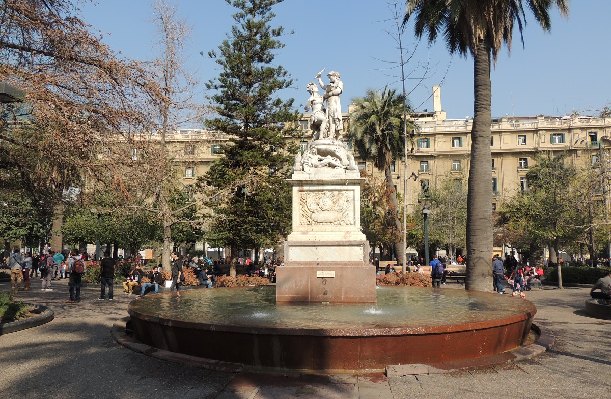
The Plaza de Armas or the Plaza de Armas is a square that was already established as the center of Santiago when the city was founded. It happened during the Spanish colonial period, when the new city was laid out with perpendicular streets around the Plaza de Armas. As the historically most important square in the city, the Spanish built a number of Santiago’s most important buildings here, including the city’s cathedral.
The atmosphere is always good in the square, where folk life thrives among artists, chess players and various cultural events. If you have time, it is therefore an attraction in itself to simply take a seat on a bench and enjoy life, the Chileans and the architecture in the beautiful and interesting setting.
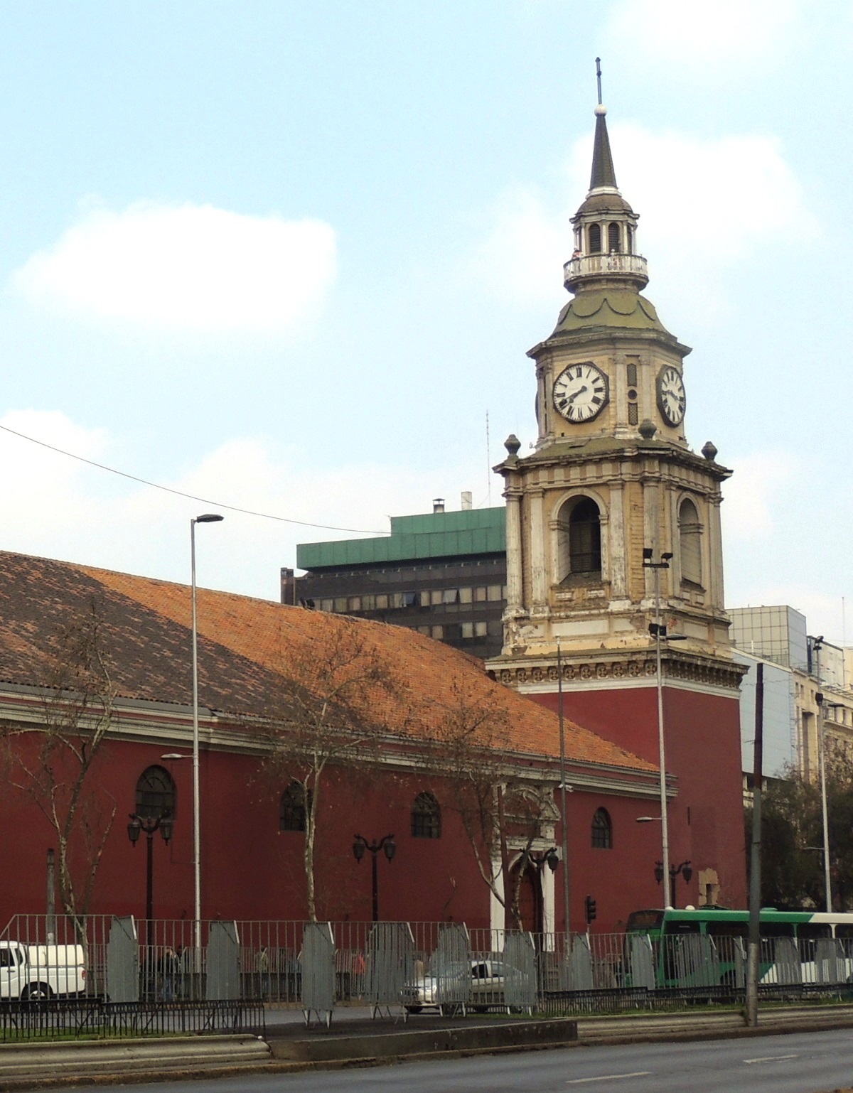
The Catedral Metropolitana is Santiago’s impressive cathedral. It is the city’s cathedral and the fifth church that has been built on this site over time. The first church building was established by the Spanish conquistador Pedro de Valdivia, who founded Santiago. Valdivia had a small church built in the central square of the new town, and this was replaced by a cathedral around the year 1600.
Santiago is located in an area that is regularly affected by earthquakes, and tremors have several times caused destruction of the Catedral Metropolitana. In 1647, an earthquake shook Santiago, and most of the cathedral was reduced to rubble. The church was rebuilt, only to be struck again by an earthquake just ten years after the first. Once again the church had to be rebuilt, and this happened in the years 1662-1687.
When another earthquake destroyed the rebuilt cathedral in 1730, Bishop Juan González Melgarejo decided to demolish the entire church and build a new one from scratch. He had drawings drawn up which were sent for royal approval in Spain. The plans were approved in 1753, and then the current cathedral was erected.
The Catedral Metropolitana was consecrated in 1775, but construction continued on the church. The Italian architect Joaquín Toesca took over construction in 1779, and he wanted to expand the cathedral to give it an expression that suited its status and location on the Plaza de Armas. Toesca was, among other things, behind the church’s new facade. The style was baroque, which in terms of construction was changed to classicism during the following construction period.
In the 19th century, further construction was carried out on the Catedral Metropolitana. The Capilla del Sagrario chapel was begun in 1846 by the architect Eusebio Chelli, and at the end of the century Ignacio Cremonesi was engaged to complete the church. He gave the cathedral a touch that was inspired by Florentine and Roman churches with stucco and ceiling frescoes.
Today you can experience the result of many years of construction in the form of a three-nave cathedral with a crypt, several altars and a fine chapel. The decoration ranges from richly decorated ceilings and chapels to the simple crypt. The style is primarily baroque with classicist features. The Capilla del Sagrario is also the place where the city’s first church was located. It was called the Iglesia Mayor and it was built shortly after the founding of Santiago.
In connection with the cathedral is the Museum of Religious Art/Museo de Arte Sagrado, which exhibits religious art such as Jesuit silverwork, paintings and sculptures. You should also take the time to visit the place’s inner courtyard, which gives a fine impression of colonial architecture.
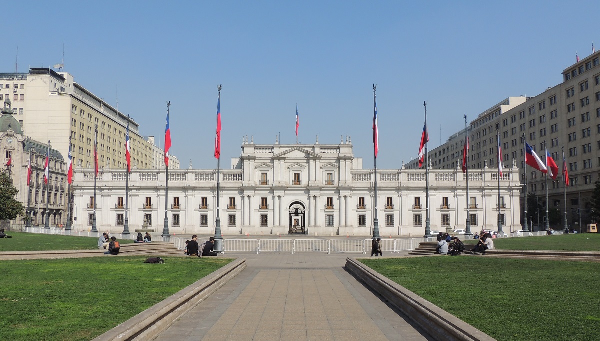
Palacio de la Moneda is a mansion that was built in 1799 as one of the last major buildings during the country’s Spanish colonial period. The mansion was built as the colonial mint, and it was the Italian architect Joaquín Toesca who was responsible for the design. Construction began in 1784, and La Moneda was completed in 1805. Materials from Chile and other parts of the world were used, and the chosen style was the neoclassicism of the time in an Italian version.
Coins were produced in La Moneda until 1929, but the mansion was also used for other purposes. In 1845, the mansion became the seat of the Chilean government, and at the same time the large building also became the residence of the President of Chile. The country’s presidents resided here, including Gabriel González Videla, who held office from 1946 to 1952. Today, the Palacio de la Moneda is still the seat of Chile’s government, and the palace is therefore also called the Palacio de Gobierno, which means the Government Palace.
Palacio de la Moneda entered the history books in 1973, when Salvador Allende was president. It happened in connection with the military coup led by Augusto Pinochet. On September 11, 1973, La Moneda was bombed and Salvador Allende shot himself in the mansion itself.
Today you can see the changing of the guard in front of the Palacio de la Moneda. In front of the southern facade is the Citizens’ Square/Plaza de la Ciudadanía, which was built in 2004-2006 as part of the preparations for the 200th anniversary of independent Chile. Here stands a colossal flag, and under the square you can experience the cultural center Centro Cultural Palacio de la Moneda, where there are regular events and activities of a different nature.
Museo Chileno de Arte Precolombino is Santiago’s museum of pre-Columbian art, and it is one of the finest of its kind in the world. The museum’s exhibition depicts the time before the Spanish colonization, and here there are many effects in wood, ceramics and metal as well as textiles. A visit gives a good impression of Central and South America’s great cultures such as the Mayans and Aztecs.
The museum building itself is interesting. The customs building Palacio de la Real Aduana was built in 1805-1807 by the military engineer José María de Atero after a design by the Italian Joaquín Toesca. After Chilean independence, the mansion was set up as a library and from 1845 as a court. The site was a courthouse until 1968, when a fire ravaged the mansion. In the 1980s, the Palacio de la Real Aduana was restored and has since then been a museum.
The church Iglesia de San Francisco is the oldest preserved building in Santiago, and it is also one of the country’s oldest constructions from the Spanish colonial period. The church was consecrated in 1622, and large parts of it remain original. The bell tower was destroyed when an earthquake hit the area in 1647, and it happened again with the otherwise rebuilt tower in 1730. The church tower that you can see today dates from the mid-19th century.
There are many interesting details in the church and in the associated monastery buildings. The church space is rustic and atmospheric, and the Virgin figure on the altar was brought to Chile by Pedro de Valdavia, who built Santiago.
In the monastery buildings, you can visit the Colonial Museum/Museo Colonial, which depicts parts of Chile and South America’s Spanish colonial period. Paintings, sculptures and furniture are some of what you can experience on a visit. There is also a small garden area for the complex, and it is a nice breather in the middle of the big city.
Barrio Lastarrio is the name of one of Santiago’s popular and cozy neighborhoods, where both locals and tourists meet in the streets and at the many outdoor dining spots that are here. You will also find a number of theaters and museums in the area, which is part of the center of Santiago.
Barrio Lastarrio emerged gradually, and as a kind of center are the square Plaza Mulato Gil de Castro and the church Iglesia de la Veracruz (José Victorino Lastarria 124). The church was built in 1852-1857 to the design of the architects Claudio Brunet de Baines and Fermín Vivaceta and is located on the site where the city’s founder, Pedro de Valdivia, lived during his time in Santiago.
Plaza Mulato Gil de Castro is a cozy square where you can sit outside and enjoy the fine surroundings, which give a fine impression of Santiago in the 1800s. The square is named after one of its historic residents, the mulatto José Gil de Castro, who was of African and Peruvian descent. Gil de Gastro was, among other things, a painter and a soldier in Chile.
Cerro Santa Lucía is a hilltop that reaches a height of 629 meters above sea level, and it is 69 meters above the surrounding streets of downtown Santiago. The hill is like a green oasis in the middle of the big city construction in the Chilean capital, and today it is set up as a park with a nice vantage point at the top, which itself is the remains of an approximately 15 million-year-old volcano.
The name Santa Lucía comes from the time of Pedro de Valdivia, when he established the town. He conquered the hill on December 13, 1540, on Saint Lucia’s Day, and it was here that he founded Santiago in 1541. Cerro Santa Lucía remained as it was in Valdivia’s time until the end of the 19th century, when the area was turned into a park.
With the layout of the park, fine facilities and an impressive flight of stairs were built, which lead to the top and thereby to the view over the capital and the Andes mountains to the east. There are several terraces where you can look over the city in several directions, and you can also see the castle Castillo Hidalgo here.
Castillo Hidalgo was built by the Spanish in 1816 as part of their struggle to preserve Chile as a Spanish colony. The castle was originally called Batería Santa Lucía, and it was to be used for the Spanish defense of Santiago. When Bernardo O’Higgins came to power in independent Chile, the defense facility was named after Manuel Hidalgo, who was a captain during the Chilean struggle for independence. Today, the castle is an event venue.
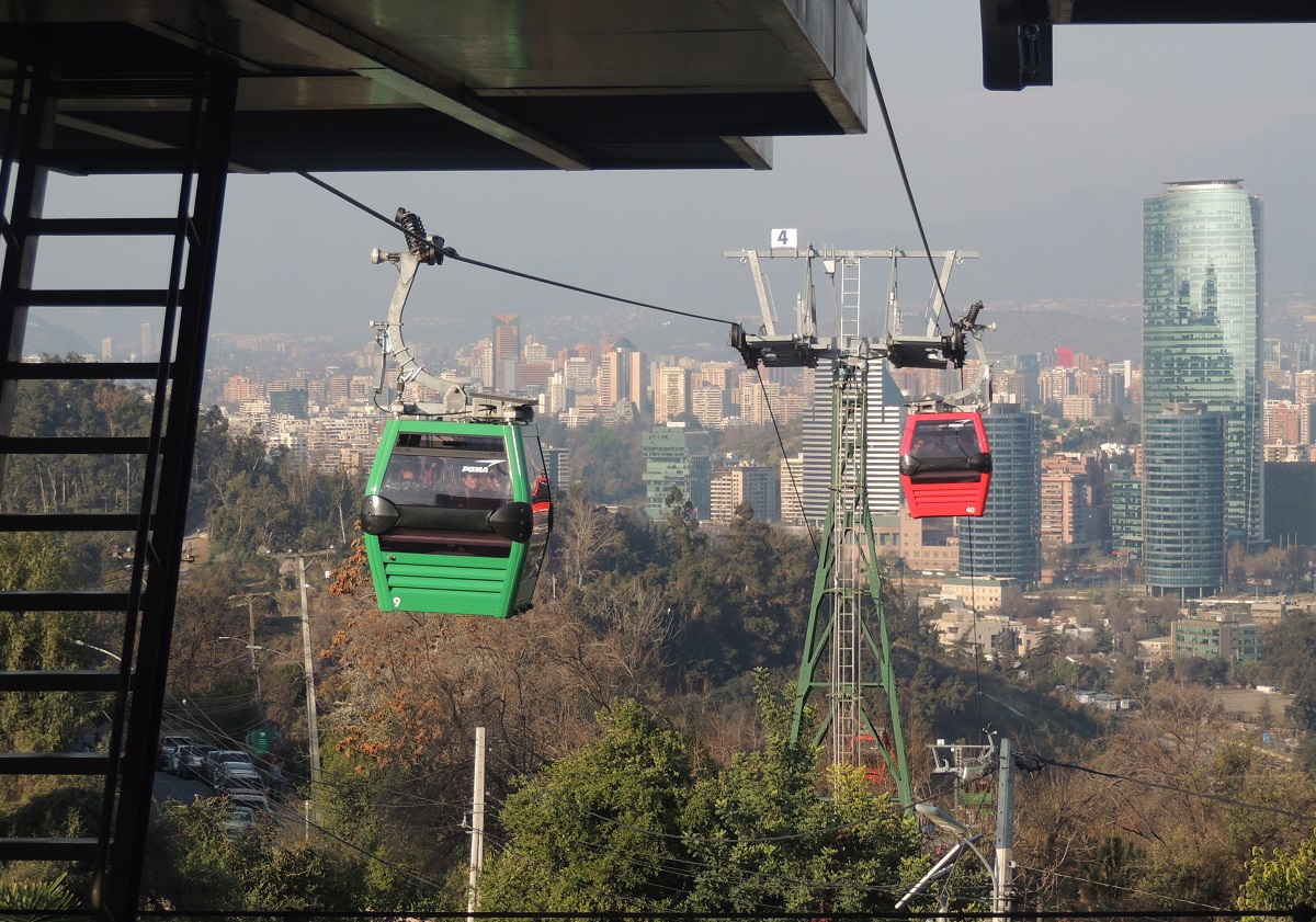
Teleférico de Santiago is a cable car and also one of the exciting ways to see the Chilean capital. The Santiago Cable Car is located in Parque Metropolitana, where it opened in 1980. On the entire 4.8 kilometer stretch, you float high above the park, and all the way there is a lovely view of Santiago and the Andes Mountains.
The cable car moves at a speed of up to 18 km/h and there are three stations; Oasis, Tupahue on Cumbre. Oasis (El Cerro, Pedro de Valdivia Norte) is the easternmost and lower station, while Cumbre is at the hilltop of Cerro San Cristóbal and the viewpoint of Terraza Bellavista. The central station Tupahue is located by the outdoor swimming pool of the same name.
The Cerro San Cristóbal ridge rises 300 meters above Santiago’s street level, and one way to get to the top is with the local funicular, called the Funicular de Santiago. It operates between the lower station, Pio Nono (Pío Nono, Manuel Mackenna), and the hilltop station (Av. Pedro Bannen). The funicular was built in 1925, and the 500-metre-long ride climbs a 45-degree incline along the way.
Casa Colorada is the name of Santiago’s best-preserved building from the country’s colonial era. The building was built in the years 1769-1779 as the residence of the country’s first president, Mateo de Toro y Zambrano. It was Joseph de la Vega who built the house with its red walls and elegant balconies.
Today, Casa Colorada houses Santiago’s city museum, and here you can take a closer look at the city’s history. The museum depicts Santiago’s almost explosive development from independence to today’s city of millions, but you can also experience the review of the city’s history from the pre-Columbian era to the Spanish colonial era.
Parque Forestal is a lovely green area located along the south side of the Mapocho River in central Santiago between Plaza Baquedano and Mapocho Train Station. The park was established in 1905 and laid out on dammed land that formerly formed part of Mapocho.
The park itself was designed by Jorge Enrique Dubois; He was a landscape architect and, among other things, was educated in the French Versailles. You can go for a walk in the park and enjoy the green surroundings, and you can also visit several museums and see various sculptures along the way on a trip here.
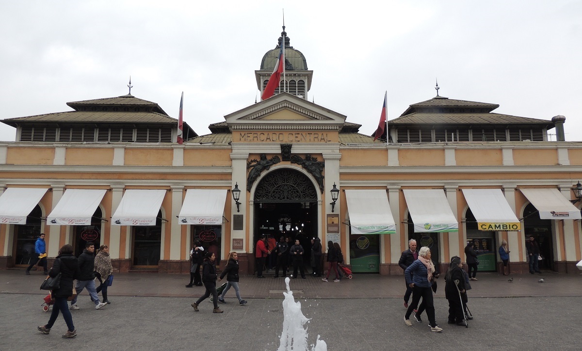
Mercado Central is Santiago’s central market. It was built in 1872, and today it is an atmospheric trading and meeting place for the city’s inhabitants. It is always lively here, and a visit gives you the opportunity to get close to the Chileans, for example at one of the market’s restaurants or to experience Chilean guitar music.
A look at the many stalls that abound with, among other things, fruit, vegetables, fish and shellfish gives you an impression of Chile’s status as a major food producer and exporter. One can also enjoy the 19th-century architecture of the market hall, which was structurally built by R. Laidlaw & Sons in Glasgow, Scotland, before the parts were shipped to Santiago.
Boulevard Avenida Libertador Bernardo O’Higgins is Santiago’s central traffic artery, also known as La Alameda. The boulevard has a length of over seven kilometers, and the stretch was until the middle of the 16th century a branch of the Mapocho river. The river branch dried up and was filled up before Bernardo O’Higgins had the Alameda de las Delicias built on the stretch.
The traffic along the street is hectic, and you sense a good city atmosphere with clusters of high-rise buildings on a walk along the boulevard, whose small parks are pleasant. On the central part you can see, among other things, a copy of a statue from Easter Island, and along the boulevard there are also monuments commemorating military heroes in Chile’s history. Near the La Moneda building you can see statues of José de San Martín, Manuel Bulnes Prieto and Bernardo O’Higgins.
Avenida Bernardo O’Higgins is named after Chilean Bernardo O’Higgins, who led Chile’s freedom struggle against the Spanish colonial rule during the Chilean War of Independence, which broke out in 1810. O’Higgins was also the country’s first leader in the so-called Patria Nueva. His reign lasted from 1817 to 1823.
Paseo Bulnes is a pedestrian street that has a special architectural design from the 1930s. Paseo Bulnes was built with buildings of the same height and uniform facades, which overall give a homogeneous and monumental impression. The construction was adopted in 1937 as part of the urban development around the government quarter at La Moneda, which lies in a straight line north of Paseo Bulnes.
The plan for Paseo Bulnes was designed by the Chilean architect Carlos Vera Mandujano, who drew inspiration from the thoughts of Austrian Karl Heinrich Brunner. Brunner worked in South America from 1929. The street was originally called Avenida Central and was planned to consist of several phases, not all of which have been realized.
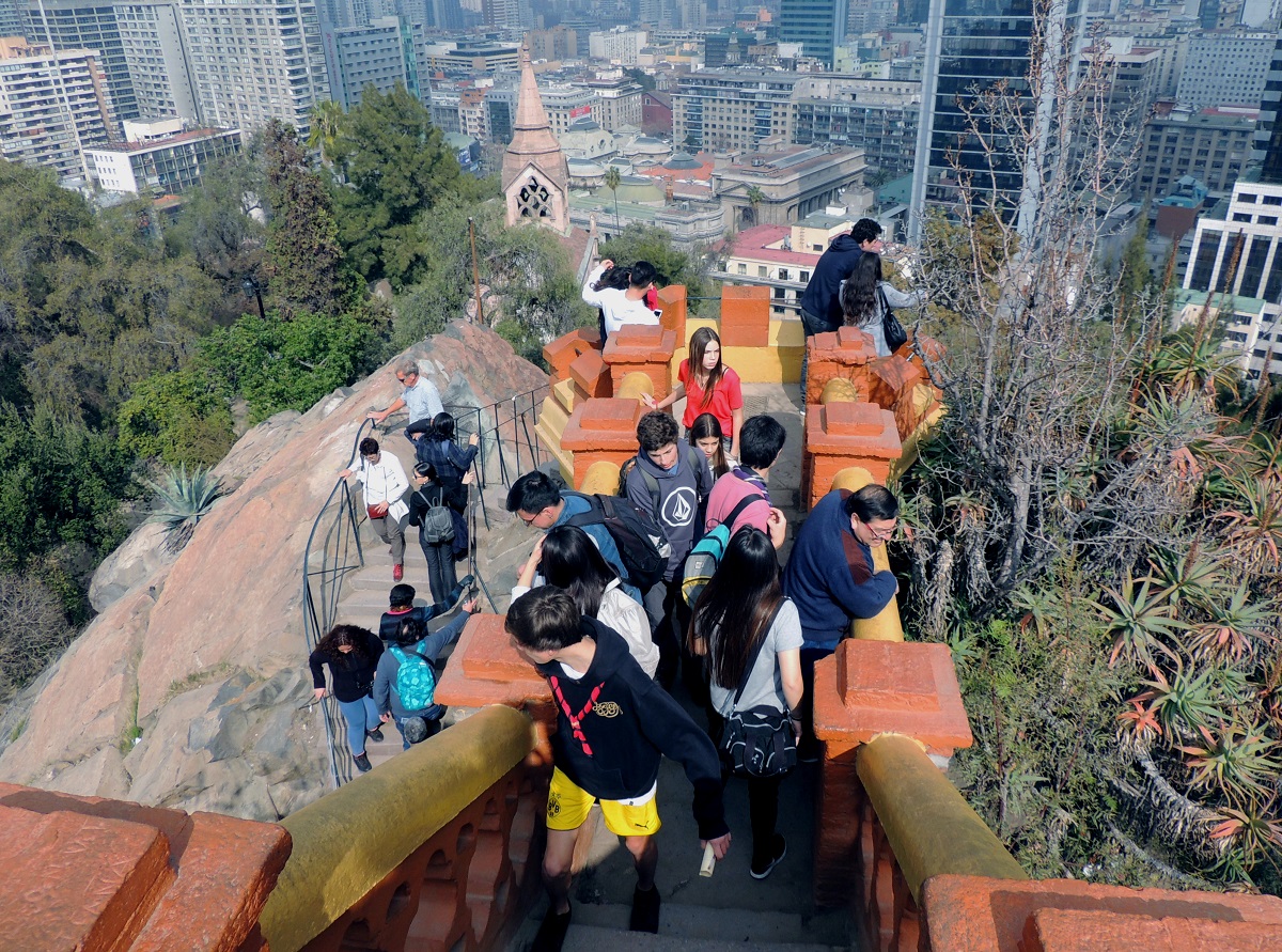
Cerro San Cristóbal is a hill whose summit is the highest point in Santiago. The peak reaches a height of 860 meters above sea level, which is about 300 higher than the street level of the city of Santiago. From the ridge there is of course a good view of the city and the surrounding area. It was the Spanish conquistadors who named the hill after Saint Christopher.
The Spanish used Cerro San Cristóbal as a lookout point over the area, and today you as a tourist can do the same. Terraza Bellavista is a good place on the hill with a view, and here you can also see a 22 meter tall statue of the Virgin Mary. In this place Pope John Paul II held Mass in 1987 and there is a chapel in the pedestal of the statue of Mary where the Pope prayed.
You can advantageously go up to the top and thereby overcome the 300 meters of altitude on foot. It’s a nice trip in the capital’s green surroundings. You can also choose to take the funicular, which runs between the Pio Nono station and the top of the hill. A third way to reach the top is with the cable car that you can take from the Oasis station (El Cerro, Pedro de Valdivia Norte).
Calle Dieciocho is a street that gives a good impression of Santiago’s past. In the decades around 1900, this is where Santiago’s wealthy families built mansions. Today, it is not one or a few individual buildings that are the street’s attractions, but rather the atmosphere and overall impression.
The starting point for the constructions started in the middle of the 19th century, when the river Mapocho was dammed. It created the boulevard Alameda de Las Delicias, and then the farmland south of Alameda was developed. The architectural model was largely Parisian quarters.
Parque O’Higgins is a 77-hectare park in the center of Santiago. It was laid out in 1873 and used to be called Parque Cousiño after the wealthy family of the same name. Today, the park is named after the freedom hero and leader Bernardo O’Higgins, who fought against the Spanish colonial rule for Chilean freedom.
The park was created in its time by Luis Cousiño, who wanted to build a large urban park in the Chilean capital, following a European model. Cousiño had taken over the land in 1870, and he engaged the French landscape architect Guillermo Renner to design the park.
Today you can experience large lawns and green park areas in Parque O’Higgins. You can also see several buildings, and there are also popular activity opportunities. These include the amusement park Fantasilandia and the indoor arena, which opened as Arena Santiago in 2006.
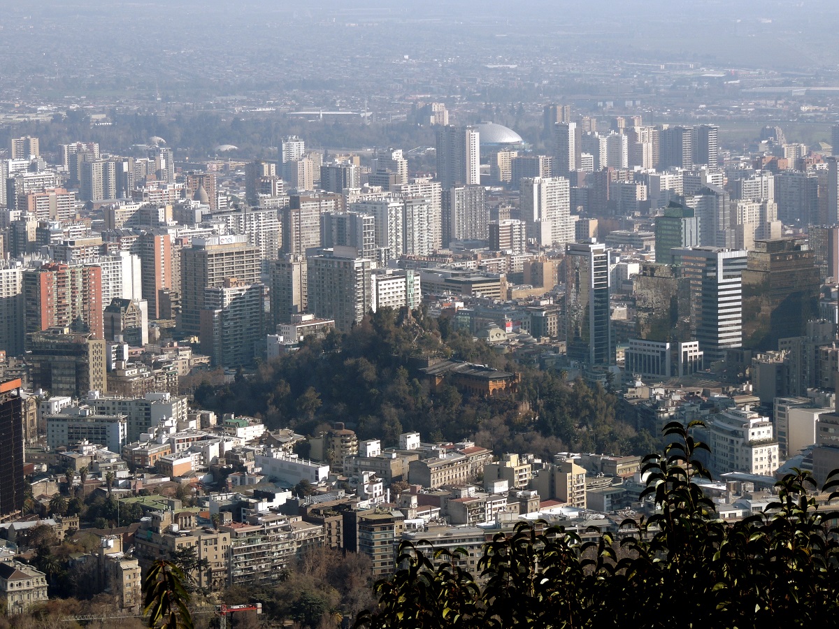
Parque Metropolitano de Santiago is a colossal green space in the Chilean capital. With an area of over 700 hectares, the park is Santiago’s largest park area, and there are many attractions and activity opportunities in the area. The hill Cerro San Cristóbal is centrally located in the park, and it is in itself the park’s biggest excursion destination.
The city government of Santiago acquired the land in the early 1900s to build a recreational area for the city’s citizens. In the 1920s, construction work was completed and the park was opened to the public, and since then more facilities have been added.
There are two public outdoor swimming pools in the Parque Metropolitano de Santiago; Piscina Tupahue and Piscina Antilén. The Tupahue bath is in green surroundings. It is 82 meters long and built in a former quarry. The Antilén bath is 92 meters long and is located on top of the Cerro Chacarillas hill, from which there is a beautiful panoramic view. One can also visit the city’s botanical and zoological gardens in Parque Metropolitano.
Parque Quinta Normal is a 35-hectare urban park in Santiago. It is a lovely oasis in the big city, and at the same time it is home to several exciting museums and other activities for children and adults. The park dates back to its foundation in 1841, when the area was laid out as greenhouses for the cultivation of various foreign plants.
In 1875, Parque Quinta Normal formed the setting for the Chilean World Exhibition Exposición International de Santiago. It was held to exhibit engineering and science to Chileans and visitors. The central exhibition building is today set up as a national museum of natural history.
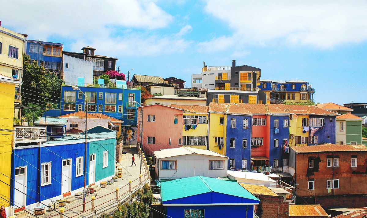
Valparaíso is one of Chile’s most important port cities, and it also ranks among the country’s most charming cities. Valparaíso was founded as a Spanish port in 1536, and its location on the Pacific coast has over the years led to growth and prosperity for long periods of time.
The city’s beautiful location on the coast has also led to a great deal of tourism, and visitors can enjoy the historic center, which is on UNESCO’s list of world heritage sites. In addition, since 1973, Valparaíso has been home to the National Congress of Chile.
Viña del Mar is Chile’s fourth largest city, and at the same time the city is the largest holiday area along the coast. Viña del Mar is very green, and it is also called the Garden City/La Ciudad Jardín by the locals. Here are many fashionable buildings and of course the long lovely beaches that the city is known for. This applies, for example, to the beach in the Reñaca area immediately north of the city centre.
Viña del Mar is also known as a gambling city, and Plaza Colombia is home to the elegant Casino de Viña del Mar, which was built as the city’s grandest building in 1930.
You can also visit the Archaeological Museum/Museo de Arqueologia e Historia Francisco Fonck (Avenida 4 Norte 784), which is known for its fine collection of effects from Easter Island. The highlight of the more than 1,000 effects is one of the few original Moai statues from the island that can be seen outside of its natural setting on Easter Island.
Among Viña del Mar’s many beautiful mansions in, among other things, Victorian style, is the Palacio Rioja (Calle Quillota 214), accessible as the museum Museo Palacio Rioja. It was built by the Spanish banker Fernando Rioja in 1906. A visit to the beautifully designed building gives a good impression of the life of the wealthy at the beginning of the 20th century.
Other beautiful mansions are Palacio Carrasco (Avenida Libertad 250) and Palacio Vergara in Quinta Vergara park. This park also houses an art museum and the city’s annual song festival. Castillo Wulff, right next to the water, is also an interesting sight.

Chilean wine is tasty and comes from many different wineries in the long country. From Santiago you can get to know some of the wine regions on your own or on one of the many organized tours you can take here.
Vineyards were planted in Chile as early as around 1550, making the country the oldest wine-producing place in the American continents. Today, there are countless wineries around Santiago, and you can visit many of them. The nearest wine region is the Maipo Valley, located in the area south, east and west of Santiago.
Maipo Valley is divided into three regions; Alto Maipo at the foot of the Andes, Central Maipo around the Maipo River and Pacific Maipo towards the Pacific coast. In all the regions there are special conditions for wine production, and you can experience this on a visit to one or more wineries.
For example, the farm Viña Santa Rita (Camino Padre Hurtado) was established in the 1880s with the import of French vines. On the site you can partly get a tour through the wine production from the fields to the storage and partly see the site’s beautiful old buildings and the large park, which was laid out by the French Guillermo Renner in 1882.
The Andes lie like an omnipresent backdrop on the entire horizon east of Santiago. The mountain range rises majestically towards the peak of Aconcagua, which lies northeast of Santiago in Argentina on the road to Mendoza. At 6,960 meters, Aconcagua is the world’s highest mountain outside the Himalayas. In clear weather, you can easily see the top of the mountain from the main road between the Chilean Los Andes and the Argentinian Uspallata.
A bus trip to Argentina is recommended if you want to cross the Andes. On the way, you will experience the steep ascent from the Chilean side towards the border pass, and then you drive slowly down to the Argentine plain. Along the way you can see, among other things, sections of the former Andean railway.
The mountain range is worth visiting in summer and winter, and you can also go skiing in the mountains close to the Chilean capital. Only 70 kilometers from Santiago is the large skiing area Valle Nevado. The place is one of Chile’s most modern, and here there are many and varied pistes. Valle Nevado is located at the foot of the mountain El Plomo.

Overview of Santiago
The Chilean capital of Santiago is a meeting place between multiple cultures, interestings sights and a magnificent scenery. Here is new and old, influenced by both Spanish and Native American culture, and the architecture has a wonderful Southern charm.
In the city, despite the large size of it, you are never far from nature. In the city itself there are large parks and several ridges, from which there are magnificent views of the city itself and the surrounding area. Between some of the hills you can even take cable cars and get a different view of the metropolis from above.
About the upcoming Santiago travel guide
About the travel guide
The Santiago travel guide gives you an overview of the sights and activities of the Chilean city. Read about top sights and other sights, and get a tour guide with tour suggestions and detailed descriptions of all the city’s most important churches, monuments, mansions, museums, etc.
Santiago is waiting for you, and at vamados.com you can also find cheap flights and great deals on hotels for your trip. You just select your travel dates and then you get flight and accommodation suggestions in and around the city.
Read more about Santiago and Chile
Buy the travel guide
Click the “Add to Cart” button to purchase the travel guide. After that you will come to the payment, where you enter the purchase and payment information. Upon payment of the travel guide, you will immediately receive a receipt with a link to download your purchase. You can download the travel guide immediately or use the download link in the email later.
Use the travel guide
When you buy the travel guide to Santiago you get the book online so you can have it on your phone, tablet or computer – and of course you can choose to print it. Use the maps and tour suggestions and you will have a good and content-rich journey.
Plaza de Armas • La Moneda • Mercado Central • Andes Mountains
Overview of Santiago
The Chilean capital of Santiago is a meeting place between multiple cultures, interestings sights and a magnificent scenery. Here is new and old, influenced by both Spanish and Native American culture, and the architecture has a wonderful Southern charm.
In the city, despite the large size of it, you are never far from nature. In the city itself there are large parks and several ridges, from which there are magnificent views of the city itself and the surrounding area. Between some of the hills you can even take cable cars and get a different view of the metropolis from above.
About the upcoming Santiago travel guide
About the travel guide
The Santiago travel guide gives you an overview of the sights and activities of the Chilean city. Read about top sights and other sights, and get a tour guide with tour suggestions and detailed descriptions of all the city’s most important churches, monuments, mansions, museums, etc.
Santiago is waiting for you, and at vamados.com you can also find cheap flights and great deals on hotels for your trip. You just select your travel dates and then you get flight and accommodation suggestions in and around the city.
Read more about Santiago and Chile
Buy the travel guide
Click the “Add to Cart” button to purchase the travel guide. After that you will come to the payment, where you enter the purchase and payment information. Upon payment of the travel guide, you will immediately receive a receipt with a link to download your purchase. You can download the travel guide immediately or use the download link in the email later.
Use the travel guide
When you buy the travel guide to Santiago you get the book online so you can have it on your phone, tablet or computer – and of course you can choose to print it. Use the maps and tour suggestions and you will have a good and content-rich journey.
Teleférico de Santiago is a cable car and also one of the exciting ways to see the Chilean capital. The Santiago Cable Car is located in Parque Metropolitana, where it opened in 1980. On the entire 4.8 kilometer stretch, you float high above the park, and all the way there is a lovely view of Santiago and the Andes Mountains.
The cable car moves at a speed of up to 18 km/h and there are three stations; Oasis, Tupahue on Cumbre. Oasis (El Cerro, Pedro de Valdivia Norte) is the easternmost and lower station, while Cumbre is at the hilltop of Cerro San Cristóbal and the viewpoint of Terraza Bellavista. The central station Tupahue is located by the outdoor swimming pool of the same name.
The Cerro San Cristóbal ridge rises 300 meters above Santiago’s street level, and one way to get to the top is with the local funicular, called the Funicular de Santiago. It operates between the lower station, Pio Nono (Pío Nono, Manuel Mackenna), and the hilltop station (Av. Pedro Bannen). The funicular was built in 1925, and the 500-metre-long ride climbs a 45-degree incline along the way.
Casa Colorada is the name of Santiago’s best-preserved building from the country’s colonial era. The building was built in the years 1769-1779 as the residence of the country’s first president, Mateo de Toro y Zambrano. It was Joseph de la Vega who built the house with its red walls and elegant balconies.
Today, Casa Colorada houses Santiago’s city museum, and here you can take a closer look at the city’s history. The museum depicts Santiago’s almost explosive development from independence to today’s city of millions, but you can also experience the review of the city’s history from the pre-Columbian era to the Spanish colonial era.
Parque Forestal is a lovely green area located along the south side of the Mapocho River in central Santiago between Plaza Baquedano and Mapocho Train Station. The park was established in 1905 and laid out on dammed land that formerly formed part of Mapocho.
The park itself was designed by Jorge Enrique Dubois; He was a landscape architect and, among other things, was educated in the French Versailles. You can go for a walk in the park and enjoy the green surroundings, and you can also visit several museums and see various sculptures along the way on a trip here.
Mercado Central is Santiago’s central market. It was built in 1872, and today it is an atmospheric trading and meeting place for the city’s inhabitants. It is always lively here, and a visit gives you the opportunity to get close to the Chileans, for example at one of the market’s restaurants or to experience Chilean guitar music.
A look at the many stalls that abound with, among other things, fruit, vegetables, fish and shellfish gives you an impression of Chile’s status as a major food producer and exporter. One can also enjoy the 19th-century architecture of the market hall, which was structurally built by R. Laidlaw & Sons in Glasgow, Scotland, before the parts were shipped to Santiago.
Boulevard Avenida Libertador Bernardo O’Higgins is Santiago’s central traffic artery, also known as La Alameda. The boulevard has a length of over seven kilometers, and the stretch was until the middle of the 16th century a branch of the Mapocho river. The river branch dried up and was filled up before Bernardo O’Higgins had the Alameda de las Delicias built on the stretch.
The traffic along the street is hectic, and you sense a good city atmosphere with clusters of high-rise buildings on a walk along the boulevard, whose small parks are pleasant. On the central part you can see, among other things, a copy of a statue from Easter Island, and along the boulevard there are also monuments commemorating military heroes in Chile’s history. Near the La Moneda building you can see statues of José de San Martín, Manuel Bulnes Prieto and Bernardo O’Higgins.
Avenida Bernardo O’Higgins is named after Chilean Bernardo O’Higgins, who led Chile’s freedom struggle against the Spanish colonial rule during the Chilean War of Independence, which broke out in 1810. O’Higgins was also the country’s first leader in the so-called Patria Nueva. His reign lasted from 1817 to 1823.
Paseo Bulnes is a pedestrian street that has a special architectural design from the 1930s. Paseo Bulnes was built with buildings of the same height and uniform facades, which overall give a homogeneous and monumental impression. The construction was adopted in 1937 as part of the urban development around the government quarter at La Moneda, which lies in a straight line north of Paseo Bulnes.
The plan for Paseo Bulnes was designed by the Chilean architect Carlos Vera Mandujano, who drew inspiration from the thoughts of Austrian Karl Heinrich Brunner. Brunner worked in South America from 1929. The street was originally called Avenida Central and was planned to consist of several phases, not all of which have been realized.
Cerro San Cristóbal is a hill whose summit is the highest point in Santiago. The peak reaches a height of 860 meters above sea level, which is about 300 higher than the street level of the city of Santiago. From the ridge there is of course a good view of the city and the surrounding area. It was the Spanish conquistadors who named the hill after Saint Christopher.
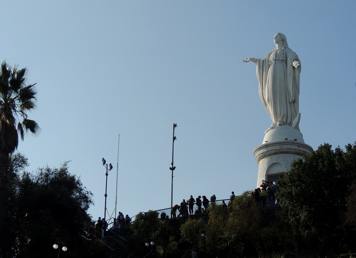
The Spanish used Cerro San Cristóbal as a lookout point over the area, and today you as a tourist can do the same. Terraza Bellavista is a good place on the hill with a view, and here you can also see a 22 meter tall statue of the Virgin Mary. In this place Pope John Paul II held Mass in 1987 and there is a chapel in the pedestal of the statue of Mary where the Pope prayed.
You can advantageously go up to the top and thereby overcome the 300 meters of altitude on foot. It’s a nice trip in the capital’s green surroundings. You can also choose to take the funicular, which runs between the Pio Nono station and the top of the hill. A third way to reach the top is with the cable car that you can take from the Oasis station (El Cerro, Pedro de Valdivia Norte).
Calle Dieciocho is a street that gives a good impression of Santiago’s past. In the decades around 1900, this is where Santiago’s wealthy families built mansions. Today, it is not one or a few individual buildings that are the street’s attractions, but rather the atmosphere and overall impression.
The starting point for the constructions started in the middle of the 19th century, when the river Mapocho was dammed. It created the boulevard Alameda de Las Delicias, and then the farmland south of Alameda was developed. The architectural model was largely Parisian quarters.
Parque O’Higgins is a 77-hectare park in the center of Santiago. It was laid out in 1873 and used to be called Parque Cousiño after the wealthy family of the same name. Today, the park is named after the freedom hero and leader Bernardo O’Higgins, who fought against the Spanish colonial rule for Chilean freedom.
The park was created in its time by Luis Cousiño, who wanted to build a large urban park in the Chilean capital, following a European model. Cousiño had taken over the land in 1870, and he engaged the French landscape architect Guillermo Renner to design the park.
Today you can experience large lawns and green park areas in Parque O’Higgins. You can also see several buildings, and there are also popular activity opportunities. These include the amusement park Fantasilandia and the indoor arena, which opened as Arena Santiago in 2006.
Parque Metropolitano de Santiago is a colossal green space in the Chilean capital. With an area of over 700 hectares, the park is Santiago’s largest park area, and there are many attractions and activity opportunities in the area. The hill Cerro San Cristóbal is centrally located in the park, and it is in itself the park’s biggest excursion destination.
The city government of Santiago acquired the land in the early 1900s to build a recreational area for the city’s citizens. In the 1920s, construction work was completed and the park was opened to the public, and since then more facilities have been added.
There are two public outdoor swimming pools in the Parque Metropolitano de Santiago; Piscina Tupahue and Piscina Antilén. The Tupahue bath is in green surroundings. It is 82 meters long and built in a former quarry. The Antilén bath is 92 meters long and is located on top of the Cerro Chacarillas hill, from which there is a beautiful panoramic view. One can also visit the city’s botanical and zoological gardens in Parque Metropolitano.
Parque Quinta Normal is a 35-hectare urban park in Santiago. It is a lovely oasis in the big city, and at the same time it is home to several exciting museums and other activities for children and adults. The park dates back to its foundation in 1841, when the area was laid out as greenhouses for the cultivation of various foreign plants.
In 1875, Parque Quinta Normal formed the setting for the Chilean World Exhibition Exposición International de Santiago. It was held to exhibit engineering and science to Chileans and visitors. The central exhibition building is today set up as a national museum of natural history.


