


Kalmar is a city on the coast in Swedish Småland. The city is one of Sweden’s oldest cities, and for centuries it was a border fortress with Denmark. In the 13th century, Kalmar traded with the Hanseatic League, and over the years a wall was constructed around the city. In 1397, the city rose to fame since the Kalmar Union between Denmark, Norway and Sweden was established at a meeting in Kalmar, and Erik of Pomerania was crowned king.
The Kalmar War was fought 1611-1613 between Denmark and Sweden, and in the decades after that the town was moved from the castle area to the island of Kvarnholmen to be more secure. With Sweden’s conquest of what is now Southern Sweden in 1658, things became more peaceful, but at the same time Kalmar lost its importance as a border fortress. The Swedish fleet was moved to Karlskrona, and the garrison was disbanded. In the 19th century, Kalmar began to grow again, and this time expansion was outside the old fortress town.
 Karlskrona, Sweden[/caption]
Overview of Karlskrona
Karlskrona is a town in Blekinge in southwestern Sweden. Its history goes back to the 17th century, when Sweden conquered southern Sweden from Denmark. North of the current city was the Danish medieval town of Lykkeby, and south of it were islands in the archipelago. In 1679 Vittus Andersson had to sell the island of Trossö to the Swedish state, which established Sweden’s primary naval station on the island. The naval harbor was protected by the archipelago, and fortifications were built to strengthen it even further.
Karlskrona was given city privileges in 1680, and bridges to the mainland were constructed from here. Neighboring towns were deprived of privileges, and citizens and merchants were forced to move to the new town, which grew rapidly to become one of Sweden’s largest cities. Over the years, however, Sweden lost its role as a great power, and Karlskrona thus lost part of its importance. However, the city retained its position as a naval base and thereby its military importance.
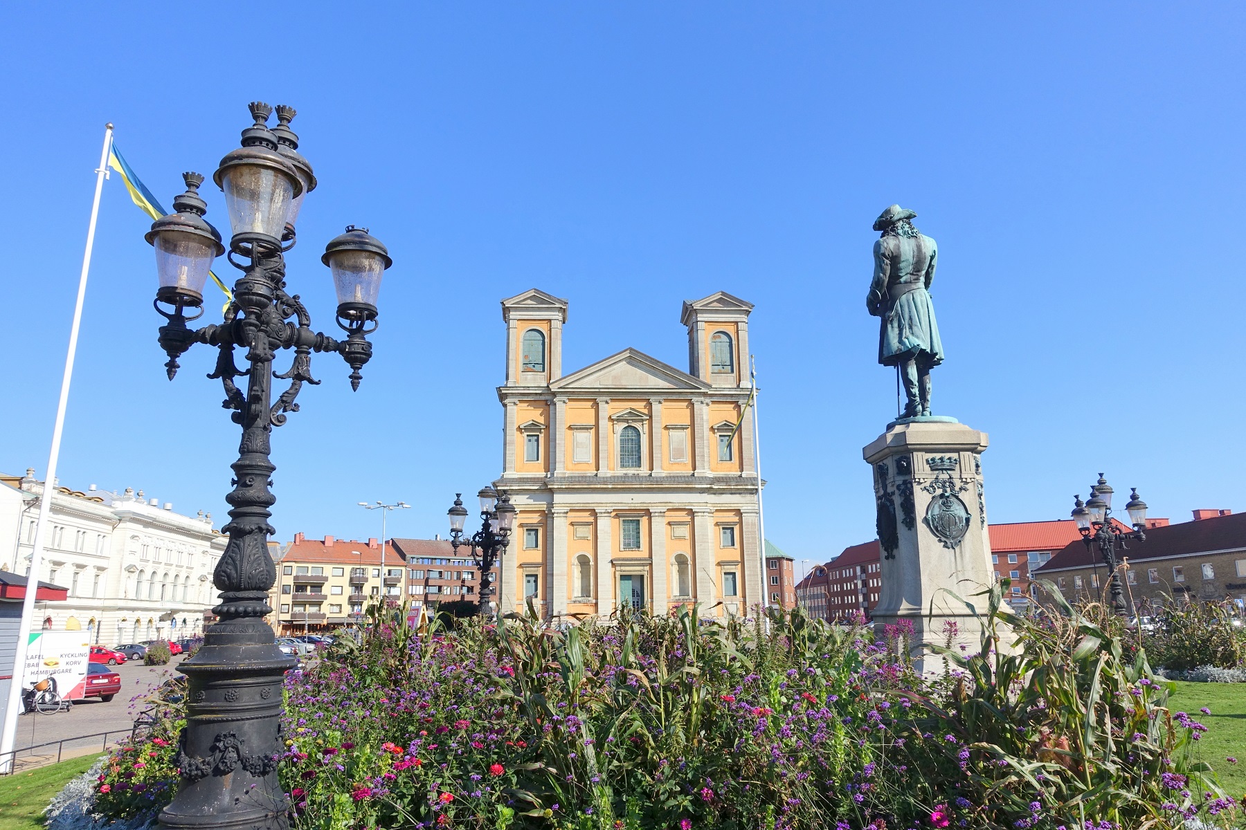
Today you can make some lovely walks in Karlskrona, which was visibly built in grand style during the Swedish era being a great European power. There streets are wide with the monumental square, Stortorget, as a centerpiece with large public buildings for the church and public administration. In the middle of Stortorget you can see Fredrykskyrkan church, which was built 1720-1744 in a very atypical Baroque for Scandinavia. Opposite Fredrikskyrkan is Karlskrona’s neoclassical town hall building, which dates from the end of the 18th century.
About the Karlskrona travel guide
Contents: Tours in the city + tours in the surrounding area
Published: Released soon
Author: Stig Albeck
Publisher: Vamados.com
Language: English
About the travel guide
The Karlskrona travel guide gives you an overview of the sights and activities of the Swedish city. Read about top sights and other sights, and get a tour guide with tour suggestions and detailed descriptions of all the city’s most important churches, monuments, mansions, museums, etc.
Karlskrona is waiting for you, and at vamados.com you can also find cheap flights and great deals on hotels for your trip. You just select your travel dates and then you get flight and accommodation suggestions in and around the city.
Read more about Karlskrona and Sweden
Sweden Travel Guide: https://vamados.com/sweden
City tourism: https://visitkarls-krona.se
Main Page: https://www.vamados.com/
Buy the travel guide
Click the “Add to Cart” button to purchase the travel guide. After that you will come to the payment, where you enter the purchase and payment information. Upon payment of the travel guide, you will immediately receive a receipt with a link to download your purchase. You can download the travel guide immediately or use the download link in the email later.
Use the travel guide
When you buy the travel guide to Karlskrona you get the book online so you can have it on your phone, tablet or computer – and of course you can choose to print it. Use the maps and tour suggestions and you will have a good and content-rich journey.


